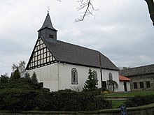
Haldem
|
Haldem
Stemwede municipality
Coordinates: 52 ° 26 ′ 19 ″ N , 8 ° 23 ′ 14 ″ E
|
|
|---|---|
| Height : | 77 m |
| Area : | 18.91 km² |
| Residents : | 1900 |
| Population density : | 100 inhabitants / km² |
| Incorporation : | 1st January 1973 |
| Postal code : | 32351 |
| Area code : | 05474 |
|
Location of Haldem in Stemwede
|
|
|
Haldem from above, in the background the Stemweder Berg
|
|
Haldem ( Low German : Hahme ) is a district of the municipality of Stemwede in the North Rhine-Westphalian district of Minden-Lübbecke and a well-known day and weekend destination on the Stemweder Berg . Around 1,900 people live here. The place has a kindergarten and a primary school.
The Schützenfest and, since 1986, the Stemweder Open Air Festival are celebrated in Haldem every year .
In Castle Haldem from the 13th century a specialized hospital for treatment and rehabilitation of addicts housed within the Maßregelvollzuges.
history
It was first mentioned in 1236 when Bishop Konrad von Minden gave the Levern monastery the tithe of Haledum .
With the territorial reform on January 1, 1973, due to the Bielefeld Act, the merger with twelve other municipalities to form the new municipality of Stemwede.
traffic
Haldem is on the state road 766. The nearest motorway junction is the transition to the B 51 / B 65 on the A 33 .
Sons and daughters of the place
- Franz von Steinaecker (1750–1832), Prussian district administrator in Western Pomerania
Web links
- Homepage of the village community Haldem eV
- Historical postcards from Haldem
- Haldem in the Westphalia Culture Atlas
Individual evidence
- ^ Federal Statistical Office (ed.): Historical municipality directory for the Federal Republic of Germany. Name, border and key number changes in municipalities, counties and administrative districts from May 27, 1970 to December 31, 1982 . W. Kohlhammer, Stuttgart / Mainz 1983, ISBN 3-17-003263-1 , p. 325 .


