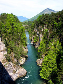
Steyr and Teichl valleys
Coordinates: 47 ° 51 ' N , 14 ° 11' E
The Steyr and Teichltal is one of the 41 Upper Austrian spatial units and extends along the Steyr and Teichl in the eastern Traunviertel .
location
The spatial unit lies in the districts of Kirchdorf and Steyr-Land .
The area of the Steyr and Teichl valleys is 42 km² and extends over around 40 km from south to north. The width is a maximum of 4 km (at Molln), usually the spatial unit is much narrower (minimum: 250 m). The deepest area is around 335 m above sea level. A. near Waldneukirchen . The highest area of the area is in the Stodertal at around 656 m above sea level. A. near the Dietlgut near Hinterstoder.
The following municipal areas have a significant share in the Steyr and Teichl valleys (in alphabetical order): Grünburg , Hinterstoder , Klaus an der Pyhrnbahn , Molln and St. Pankraz .
The spatial unit is surrounded by the following Upper Austrian spatial units (from north to south): Lower Enns and Steyrtal , Enns and Steyrtal Flysch Mountains , Enns and Steyrtal Pre-Alps , Salzkammergut Pre-Alps , Kalk-Hochalpen , Sengsengebirge and Windischgarstner Basin .
The Steyr and Teichl valleys are divided into two sub-units:
- River valley with gorges and wood along the banks
- Grassland dominated landscape with settlement area
Characteristic
- Gorge-like valley course along the Steyr, Teichl and Krummer Steyrling between the Stodertal and Lower Steyrtal. Bergland rises on both sides. The terraces and the mountainous areas merge partly with one another. The deeply cut conglomerate canyons are 100 to 200 meters wide and 30 meters deep.
- Steyr breakthrough near the Steyrsberg (Hinterstoder) with the Stromboding waterfall is scenic.
- Many small, natural streams flow into Steyr and Teichl. Occasional waterfalls occur at the confluence.
- Good fishing area (e.g. grayling in the Steyr).
- The Klaus power plant forms a backwater up to the mouth of the Teichl (bathing pond). Other power plants also line the spatial unit.
- Riparian forest is locally very limited. There is species-rich snow heather - pine forests and hornbeam forests .
- Unforested terrace areas are mainly used as grassland. The cultural landscape is well preserved and has many structural elements ( orchards ). At the edge of the terrace there is still semi-arid grass , poor grass and colorful, greasy meadows .
- Several larger villages with significant urban sprawl effects.
- Important traffic axes ( Pyhrn Autobahn (A 9) and Pyhrnbahn ) cut through the Teichltal in particular. Noise affects the landscape and animal ecology of the habitat.
- Industrial gravel mining near the Steyr Gorge affects the landscape.
- Tourism through many leisure activities (boat trips, rafting , fishing, fly fishing).
literature
- Office of the Upper Austrian Provincial Government, Nature Conservation Department (Ed.): Nature and Landscape / Guiding Principles for Upper Austria. Volume 34: Steyr and Teichltal spatial unit . Krems and Linz 2007 ( pdf [accessed on February 17, 2017]).
Web links
- Map of the Steyr and Teichltal spatial unit. In: DORIS . Retrieved December 1, 2014 .
- Steyr and Teichl valleys. In: Nature and Landscape in Upper Austria. Retrieved December 1, 2014 .


