
Stoffelbach (Reppisch)
| Stoffelbach | ||
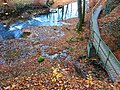
 Middle reaches of the Stoffelbach as seen from a small wooden bridge in November |
||
| Data | ||
| Water code | CH : 12155 | |
| location | Switzerland | |
| River system | Rhine | |
| Drain over | Reppisch → Limmat → Aare → Rhine → North Sea | |
| source | in the Honeret forest area 47 ° 23 ′ 5 ″ N , 8 ° 24 ′ 22 ″ E |
|
| Source height | 492 m above sea level M. | |
| muzzle | at Dietikon in the Reppisch coordinates: 47 ° 23 '34 " N , 8 ° 23' 47" E ; CH1903: 672 312 / 249534 47 ° 23 '34 " N , 8 ° 23' 47" O |
|
| Mouth height | 406 m above sea level M. | |
| Height difference | 86 m | |
| Bottom slope | 66 ‰ | |
| length | 1.3 km | |
| Catchment area | approx. 45 ha | |
| Right tributaries | Allmendlibach, Lotterbach | |
| Communities | Dietikon | |
 Stoffelbach in the same place as in the picture above in March |
||
The Stoffelbach is a 1.3 kilometer long right tributary of the Reppisch in the municipality of Dietikon in the canton of Zurich . It is the most important outflow of the Honeret forest area , in which it exclusively runs, and, along with the Tobelbach and the Aegertenbach, is one of the three streams in this forest that flow into the Reppisch.
The stream carries little water in the summer months and then looks more like a trickle. Except for two short sections in which it has overturned, it runs close to nature. The Federal Office for the Environment characterizes the Stoffelbach as a steep, small river of the colline, carbonate central plateau.
The name Stoffelbach comes from Stoffel and means heel of a mountain, but also step, which can be traced back to the course of the stream, which descends in steps. In the past, the brook was also called Tobelbach and today's neighboring Tobelbach was still nameless. The surrounding corridor Stoffelbrunnen was first mentioned in a document in 1560.
The neighboring quarter and a stop of the Bremgarten-Dietikon-Bahn are named after the Stoffelbach .
geography

course
The stream rises in the Honeret about 450 meters east of the forest hut Lorenzhütte in a pipe that crosses under Kreuzplatzstrasse , at 492 m above sea level. M. The Stoffelbrunnen is located in the Waldflur Obem Züriweg , where the old path leads to Zurich . Above the actual source, the stream branches into several, mostly waterless ditches, the longest being around 270 meters long. These extend west of the Ried im Honeret , a flat moor , and the ditches of the Tobelbach, which are directly adjacent to the south.
From here it flows in a north-easterly direction and at the same time overcomes several meters in altitude in a small ravine, before crossing under the Stoffelbrunnenstrasse at 474 m above sea level. M. takes up the Allmendlibach (also Chüeholzbach) from the right. This brook, which only carries water periodically, has its source in the Ried am Honeret on Urdorfer municipality soil and is also called Stoffelbach there. From here, the stream flows through a small valley, which gently slopes to 496 m above sea level in the west . M. rises. The slope in the east, which is called Sonnenrain , is only slightly steeper and reaches a height of 500 m above sea level at Buechholz . M.
After the confluence of the Allmendlibach , the brook turns to the northwest and flows through the forest field Stoffelbrunnen in the northern part of the Honeret . The stream now follows a short distance to the left side, the Stoffel Brunnenstrasse or right hand high on the hillside, the Sunwell Street . On this section, the stream is only crossed once by a small, wooden footbridge. Immediately afterwards it reaches the settlement boundary, where it runs about 10 meters within the edge of the forest.
It passes under the tracks of the Bremgarten-Dietikon-Bahn and the Bernstrasse , which is shown here as Hauptstrasse 1 , and now forms the deepest ravine of its stream. When crossing the Eichelwaldstrasse forest road , this ravine is heaped up for about 35 meters and the stream runs in a pipe. At the end there is a 60 centimeter high concrete fall. A little later it takes the Lotterbach from the right, which is overturned along its entire course. It now deviates from the edge of the forest and flows westwards, where it comes to the Langmatt corridor after a 3.5 meter high waterfall at 406 m above sea level. M. flows into the lower reaches of the Reppisch.
Catchment area
The approximately 0.45 square kilometer catchment area is almost completely forested, only the Lotterbach tributary crosses the settlement area. The highest point is 520 m above sea level. M. , the highest named elevation is 500 m above sea level. M. Hohe Buechholz. The catchment area also includes the Ried im Honeret moor in Urdorf, directly on the municipal border with Dietikon, which is of supra-municipal importance. Parts of it are protected as a forest reserve .
In the north and east lies the catchment area of the Schäflibach , which drains into the Limmat, and in the west that of the somewhat longer Tobelbach , which also flows into the Reppisch.
Tributaries
- Allmendlibach (also called Chüeholzbach), from the right and east to 474 m above sea level. M. shortly after the Stoffelbach source, 0.34 km long and approx. 0.05 km². Rises from the Ried moor in Honeret at about 494 m above sea level. M. and only carries water periodically. An unmapped stream flows into the lower reaches, which also only carries water periodically.
- Lotterbach, from the right and northeast to 418 m above sea level. M. after crossing the Eichelwaldstrasse , 0.47 km long and approx. 0.1 km². Rises on the edge of the Honeret forest below the Sonnenrain reservoir at 449 m above sea level. M. and overturned through the Dietiker Quartier Stoffelbach . The stream used to flow openly through the fields of the Mösli corridors , which is now called Stoffelbach , Lachen and Oberfeld , before flowing into the Reppisch in the Oberdorf . Until 1954, it flowed openly through the Rose and Lachen districts that already existed at that time .

geology
In its upper course and in parts of its lower course the brook has eaten itself into Quaternary Würm - moraines sediment consisting of clay, silt and sand. At the confluence of the Allmendlibach there are upper freshwater molasses formed in the Tertiary and those from the Tortonium at the mouth .
flora
The Stoffelbach mostly flows through (typical) woodruff - beech forest , in the upper section of the stream with lungwort , in the lower section with forest ziest . The arum- beech forest also occurs on its upper course, while its entire lower course is characterized by maple - ash forest with ringelkraut .
photos

Upper course of the Stoffelbach after the confluence of the Allmendlibach

Middle reaches of the Stoffelbach

same waterfall in October
Estuary in November


See also
Web links
- Course of the Stoffelbach on GIS Zurich
- Course of the Stoffelbach on the geoserver of the Swiss federal administration
swell
Individual evidence
- ↑ a b c d e f individual records of the geographic information system of the canton of Zurich
- ↑ a b c Geoserver of the Swiss Federal Administration ( information )
- ↑ a b c Geographic information system of the Canton of Zurich measured according to contour lines
- ↑ New Year's Gazette from Dietikon 1958. (PDF) History of the forests of Dietikon by Karl Heid. Retrieved October 10, 2015 .
- ↑ a b Neujahrsblatt von Dietikon 1949. (PDF) Place and field names of Dietikon by Karl Heid. Retrieved October 10, 2015 .
- ↑ Own observation