Great Belt
| Great Belt | ||
|---|---|---|
| Belte and Sunde in Denmark and the southwestern Baltic Sea | ||
| Connects waters | Kattegat | |
| with water | Baltic Sea | |
| Separates land mass | Zealand | |
| of land mass | Funen | |
| Data | ||
| Geographical location | 55 ° 20 ′ N , 11 ° 0 ′ E | |
|
|
||
| length | 70 km | |
| Greatest depth | 60 m | |
| Coastal towns | Korsør , Nyborg | |
| Islands | Agersø , Omø , Romsø , Sprogø | |
| bridges | Storebælt Bridge | |
| tunnel | Railway tunnel | |
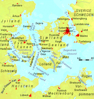
The Great Belt (Danish: Storebælt ) is the strait between the Danish islands of Fyn ( Danish: Fyn ) in the west and Zealand (Danish: Sjælland ) in the east. In a broader sense, the Langelandsbelt (Danish: Langelandsbælt ) , which is only 10 to 12 km wide to the south, between Langeland in the west and Lolland in the east is also included. Between Zealand and Lolland, the Great Belt expands eastwards to Smålandsfarvandet (translated: Smålandsfahrwasser), which has the eastern exits Storstrømmen (to the east) and Guldborgsund (to the southeast) on both sides of the island of Falster . The northern continuation of the Great Belt into the Kattegat between the island of Samsø in the west and the Røsnæs peninsula belonging to Zealand and the island of Sejerø in the east is called Samsø Bælt .
Detmar von Lübeck calls the Great Belt Baltesund (Baltic Sound) in his chronicle in the 14th century .
The Great Belt is up to 60 m deep, 20 to 30 km wide and in the narrower sense 70 km long, with the Langelandsbelt about 100 km.
According to the definition of the International Hydrographic Organization , the Great Belt ends in the south on a line from Gulstav, the southernmost point of Langeland, to Kappel Kirke, the most south-westerly point of Lolland.
traffic
The ferry route between Kiel and Oslo runs through the Great Belt . Overall, around half of the shipping traffic between the Kattegat and the Baltic Sea uses this strait.
The most important ferry crossing across the Great Belt had existed between Korsør and Nyborg since the 19th century. In 1997 a railway tunnel was opened here and in 1998 the Storebæltsbroen (Great Belt Bridge). There is a ferry across the Langelandsbelt between Spodsbjerg on Langeland and Tårs on Lolland.
ecology
About three quarters of the water exchange between the oxygen-poor Baltic Sea and the oxygen and salt-rich ocean takes place through the Great Belt. The salt-rich and therefore heavier water from the Kattegat flows southwards and the low-salt and therefore lighter Baltic Sea water above it flows northwards. Measurements before and after the construction of the Storebælt Bridge have shown that the bridge piers swirl the water layers, which were previously clearly separated from each other. It is feared that this will slow down the two countercurrent currents and that less oxygen-rich water will enter the Baltic Sea. Long-term comparisons have shown that the influx of oxygen-rich water through the Danish straits and its fluctuations have a strong impact on the fauna of the Baltic Sea.

