
Stupferich
|
|
||
|---|---|---|
| District of the city of Karlsruhe | ||
|
||
| Basic data | ||
| Geographer. location | 48 ° 57 ′ N , 8 ° 30 ′ E | |
| height | 215 m above sea level NN | |
| surface | 6.4999 km² | |
| Residents | 2,762 (as of March 31, 2017) | |
| Population density | 425 inhabitants per km² | |
| Incorporated | January 1, 1972 | |
| Postcodes | 76228 | |
| prefix | 0721 | |
| Transport links | ||
| Highway |
|
|
| Bus routes | 23 47 118 | |
| Night traffic | NL6 | |

Stupferich is a district of the Baden-Württemberg city of Karlsruhe .
Stupferich is located on the south-eastern edge of the urban area. Stupferich was an independent municipality until January 1, 1972, but was then incorporated into the city of Karlsruhe and since then has been one of the so-called "mountain villages" of Karlsruhe.
The name Stupferich is derived from the Old High German Stuotpferrich , or Stutpferrich ( stuot = "mare", pfarrih = pferrich = "pen"). This is how Reginboto von Malsch called his development settlement, where he had horse breeding carried out.
In 2000 Stupferich celebrated the 900th anniversary of the community. The first documentary mention of the community in a donation book from Hirsau Monastery dates back to 1110.
Stupferich can be reached via Rittnertstraße from Durlach (bus 23), via Grünwettersbach from Wolfartsweier (bus 47 from the main train station and Zündhütle ) or the Karlsbad junction on federal motorway 8, which is around one kilometer away .
The originally predominantly agricultural Stupferich now houses not only an abas branch, but also the Vogel-Sitz company and the headquarters of the Physik Instrumente (PI) company in the area south of the A 8.
Transportation
Stupferich is connected to the network of the Karlsruhe Transport Association (KVV). There is a bus connection with line 47 to the Zündhütle (tram stop) or to the main train station and with bus line 23 to Durlach . From Monday to Friday there has been a new bus connection to the neighboring district of Karlsruhe since December 2017 : bus line 118 to Langensteinbach to the local Langensteinbach train station and to the SRH clinic. The school bus also drives to the Langensteinbach school center.
The former Stupferich Castle is located south of the district .
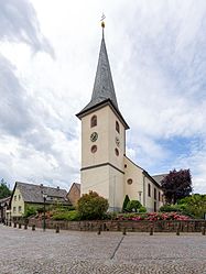
The Catholic Church of St. Cyriacus
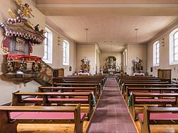
The interior of the church

The local road in Stupferich
.jpg)
.jpg)

Individual evidence
- ^ Federal Statistical Office (ed.): Historical municipality directory for the Federal Republic of Germany. Name, border and key number changes in municipalities, counties and administrative districts from May 27, 1970 to December 31, 1982 . W. Kohlhammer, Stuttgart / Mainz 1983, ISBN 3-17-003263-1 , p. 473 .
- ↑ Description of the new bus lines 117 and 118 on wettersbach-online.de . Retrieved December 28, 2017.
Web links

Inner districts: Downtown East | Downtown West | Nordstadt | Northwest City | Oststadt | Südstadt | Southwest city | West town
Outer districts: Beiertheim-Bulach | Daxlanden | Durlach | Grötzingen | Grünwettersbach | Green angle | Hagsfeld | Hohenwettersbach | Knee rings | Mühlburg | Neureut | Oberreut | Palmbach | Rintheim | Rüppurr | Stupferich | Waldstadt | Weiherfeld-Dammerstock | Wolfartsweier