
Südstadt (Karlsruhe)
|
|
||
|---|---|---|
| District of the city of Karlsruhe | ||
|
||
| Basic data | ||
| Geographer. location | 49 ° 0 ′ N , 8 ° 24 ′ E | |
| surface | 2.2049 km² | |
| Residents | 18,613 (as of June 30, 2014) | |
| Population density | 8,442 inhabitants per km² | |
| Postcodes | 76137 | |
| prefix | 0721 | |
| Transport links | ||
| Federal road |
|
|
| Light rail | S 1 S 11 S 4 S 7 S 8 | |
| tram | 2 3 4 5 6 | |
| Bus route | 10 | |
| Night traffic | NL5 | |

The southern part of Karlsruhe is a district that lies between the eastern city center and the main train station .
history
After the first train station in the city of Karlsruhe was inaugurated on April 1, 1843, a settlement of the railway workers was formed in the area of the former "Augarten". On March 13, 1857, the city submitted a development plan that provided for a southward expansion of the city. In this context, the first workers' apartments were built in 1858 and finally the first street in the so-called "Bahnhofsviertel" was built in 1860. From 1849 to 1997 there was a repair shop of the Badische Staatsbahn (after 1920 Deutsche Reichsbahn, from 1950 Deutsche Bundesbahn) in the southern part of the city .
The foundation stone of the first church in the southern part of the city for the Protestant Johanniskirche was laid on April 28, 1887. It was designed by Ludwig Diemer and inaugurated two years later on April 1, 1889. In 1891 the first service was held in the newly built Catholic Church of Our Lady , which was consecrated on October 16, 1892. The St. John's Church was destroyed in World War II and rebuilt by 1950.
From the beginning, the station district had to struggle with numerous problems. The Südstadt was cut off from the rest of the city by the tracks of the station, as there were only three level crossings , which were closed more and more frequently due to the increasing traffic. The plans for an underground tunnel were discarded because the costs were too high and a bridge was built, but because of the steep incline, horse-drawn vehicles could not cross the bridge. As the traffic continued to increase and a major expansion of the tracks became necessary, the station was finally moved south in 1913. Today the Baden State Theater and the administration building of the former Oberpostdirektion Karlsruhe are located on the former route . In addition to the traffic problems, the living conditions of the population in the tenements were poor: in 1897 there was only 16 square meters of living space per person, in the rest of the city 30 square meters.
Street scene

The middle part of Südstadt is characterized by narrow streets with Wilhelminian style apartment buildings , a multicultural population and international cuisine. The focal point is Werderplatz , named after August von Werder .
In the west it touches the city garden and zoo . There are a number of commercial buildings along Ettlinger Straße, including a hotel and the listed Mona Versand high-rise from 1960. The Schauburg cinema is located on Marienstraße . The building used to house the famous Apollo Theater until it was converted into a cinema in the 20th century. The Schauburg is an art house cinema recognized beyond the city limits, which is regularly awarded for the quality of the program selection.
The freight yard and the Karlsruhe repair shop were in the east until 1997 . The City Park development area has been under construction here since 2004 .
City Park

After the repair shop was closed, 335,200 square meters of building land became available. In this area, around 3,000 apartments will be built by 2015 in a newly created district. In addition, a new city park will be created and the existing Ostauepark will be expanded, the water tower built in 1877 and the canteen of the repair shop, which is used today by the Bürger-Gesellschaft Südstadt eV for events, will be retained. When the project is completed in 2015, the area will have a tram connection, a kindergarten and a primary school . The district should offer space for around 6,000 people.
Indians

The nickname of the Südstadt residents is " Indian ". The origin of this connection is unclear, a guest appearance by Buffalo Bill in 1889 is suspected. Another theory assumes that the railway workers were called "Indians" because of their soot-smeared faces.
The landmark of the southern part of the city is the Indian fountain on Werderplatz, which was built by August Meyerhuber in 1924–1927 according to plans by the city planning director Friedrich Beichel , alluding to this name . The fountain is also shown on the coat of arms of the southern city. In addition, a small Indian fountain was built in 1925 by Otto Feist and Fritz Schoch in Baumeisterstraße.
In 2004 Norbert Huwer erected the “Three Arrows for the South City” memorial with donations from the Bürger-Gesellschaft Südstadt eV, which depicts three meter-high Indian arrows stuck in the ground.

Indian fountain on Werderplatz

Schützenstrasse

Catholic Church of Our Lady
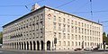
Oberpostdirektion
.jpg)


Web links
Individual evidence
- ↑ Stadtchronik Karlsruhe ( page no longer available , search in web archives ) Info: The link was automatically marked as defective. Please check the link according to the instructions and then remove this notice. .
- ↑ The estate of the Schmeiser photo studio ( Memento of the original dated February 9, 2010 in the Internet Archive ) Info: The archive link was inserted automatically and has not yet been checked. Please check the original and archive link according to the instructions and then remove this notice. . Website of the city of Karlsruhe, as of April 13, 2005, accessed on January 25, 2011.
- ^ Günther Oetzel: The beating heart of the city. Urban space and industrial mobility. The Karlsruhe station question. KIT Scientific Publishing, Karlsruhe 2005, ISBN 3-937300-45-7 (digitized as PDF document with approx.7.54 MB) , p. 29f.
- ↑ Archived copy ( memento of the original from April 29, 2013 on WebCite ) Info: The archive link was inserted automatically and has not yet been checked. Please check the original and archive link according to the instructions and then remove this notice.
- ↑ http://www.ka-news.de/region/karlsruhe/City-Park-Rundgang;art6066,59800
- ^ Klaus E. Lindemann, Thomas Lindemann: Karlsruhe. Diary of the fan-shaped city 2008/2009 . 2008, ISBN 9783881905299 , pp. 55-59.
- ↑ coat of arms-Südstadt. City of Karlsruhe, accessed on April 5, 2019 .

Inner districts: Downtown East | Downtown West | Nordstadt | Northwest City | Oststadt | Südstadt | Southwest city | West town
Outer districts: Beiertheim-Bulach | Daxlanden | Durlach | Grötzingen | Grünwettersbach | Green angle | Hagsfeld | Hohenwettersbach | Knee rings | Mühlburg | Neureut | Oberreut | Palmbach | Rintheim | Rüppurr | Stupferich | Waldstadt | Weiherfeld-Dammerstock | Wolfartsweier