Hagsfeld
|
Hagsfeld |
||
|---|---|---|
| District of the city of Karlsruhe | ||
|
|
||
| Basic data | ||
| Geographer. location | 49 ° 2 ′ N , 8 ° 27 ′ E | |
| height | 114 m above sea level NN | |
| surface | 7.1762 km² | |
| Residents | 7,119 (as of June 30, 2014) | |
| Population density | 992 inhabitants per km² | |
| Incorporated | April 1, 1938 | |
| Postcodes | 76139 | |
| prefix | 0721 | |
| Transport links | ||
| Highway |
|
|
| Federal road |
|
|
| Light rail | S 2 | |
| tram | 4th | |
| Bus routes | 31 32 | |
| Night traffic | NL4 | |
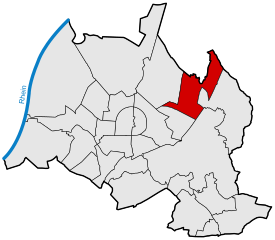
Hagsfeld is a district of Karlsruhe in Baden-Württemberg and borders in the north on the Stutensee district of Blankenloch , in the northeast on Weingarten and the following Karlsruhe districts: in the east on Grötzingen , in the southeast on Durlach , in the south on Rintheim and in the west on the Waldstadt .
history
In 991 Hagsfeld is mentioned for the first time as "Habachesfelt". According to tradition, the name comes from the fact that a new community was built in a field full of habachen (probably trees). On December 2, 1261, Pope Urban IV confirmed the affiliation of "Hagesvelt" with all its courts to the Gottesaue monastery . Margrave Jakob I bequeathed Hagsfeld to his son Georg in 1453 . The Laurentiuskirche and the cemetery were also mentioned in 1499 as the property of the Gottesaue monastery.
The Thirty Years War also claimed many victims in Hagsfeld, so that in 1650 there were still 45 inhabitants. In 1851 Hagsfeld comprised 110 houses in which a total of 908 residents lived.
The Hagsfeld volunteer fire brigade was founded in 1874 and the first train station was built in 1895. The first gas line followed in 1909, and the population increased to 2,000 in 1911.
During the Nazi era , free gymnastics and the workers' sports club were banned in 1933. On April 1, 1938, Hagsfeld was incorporated into the city of Karlsruhe with 2962 inhabitants. On 24./25. April 1944 misdirected British planes unloaded the bombs destined for the Karlsruhe station area over Hagsfeld, among other places; the place was largely destroyed.
coat of arms
Blazon : "A silver village symbol ( house brand ) in blue , consisting of a tiller head shaft with a central cross rung and rafter foot."
research
The Technology Center Water (TZW) of the DVGW is located in the Hagsfeld district. Research focuses on microbiology and analytics . Regional waters are also continuously examined.
Sports
Soccer, tennis
Football is only played in the Allgemeine Sportverein (ASV) Hagsfeld . The club was founded in 1907 and has two floodlit grass pitches.
In addition to football, the club also offers a tennis department, for which 6 tennis clay courts can be used.
Handball
The Vereinte Turnerschaft Hagsfeld (VTH) was the only club with a handball department in Hagsfeld. However, this no longer exists since 2004.
education
After a teacher was mentioned for the first time in 1656, the first schoolhouse was built in 1754.
The only school in Hagsfeld is the Hagsfeld primary school with currently around 300 students. The Karl Stockmeyer School, a Parzival school , is under construction. All other types of school are located in the neighboring district of Waldstadt . There is a grammar school (Otto Hahn grammar school), two elementary and secondary schools with a Werkrealschule (Ernst Reuter school as an all-day school and the Eichendorff school), a Waldorf school and a European school .
Kerwe
Every year on the second weekend in September in Hagsfeld there is a kerwe on the premises of the school and the fire brigade.
literature
- Gerhard Friedrich Linder: A thousand years of Hagsfeld. The story of a village . ed. from the city of Karlsruhe - city archive. Badenia Verlag, Karlsruhe 1991. ISBN 978-3-89735-335-0 .


