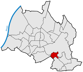
Wolfartsweier
|
Wolfartsweier |
||
|---|---|---|
| District of the city of Karlsruhe | ||
|
|
||
| Basic data | ||
| Geographer. location | 48 ° 58 ′ N , 8 ° 27 ′ E | |
| height | 133 m above sea level NN | |
| surface | 2.0058 km² | |
| Residents | 3,154 (as of March 31, 2017) | |
| Population density | 1,572 inhabitants per km² | |
| Incorporated | 1st January 1973 | |
| Postcodes | 76228 | |
| prefix | 0721 | |
| Transport links | ||
| Federal road |
|
|
| tram | 2 8 | |
| Bus routes | 24 27 44 47 47A 107 118 | |
| Night traffic | NL1 NL6 | |
Wolfartsweier is a district of the Baden-Württemberg city of Karlsruhe .
history
Wolfartsweier is first mentioned in 1261 as Wolvoldiswilere . In 1535 Wolfartsweier fell to the margraviate of Baden-Durlach. At the end of the Thirty Years' War in 1648, only seven (male adult) residents are said to have been alive in Wolfartsweier, of whom Siebenmannstrasse in Oberdorf commemorates. The community grew to 370 inhabitants in 1837 and 506 inhabitants in 1901. From 1907 to 1971 Dynamit Nobel AG (Genschow) operated an ammunition factory in the Zündhütle area. The outdoor pool was opened in 1935. Wolfartsweier was incorporated into the city of Karlsruhe on January 1, 1973. In 2015, a gas explosion in an eight-family house, in which four people died, caused a stir. In the 2019 local council election, the SPD achieved an absolute majority with 59.6 percent.
Attractions
- Primer
- Kindergarten Wolfartsweier , based on a design by Tomi Ungerer in the shape of a cat
- Wolfartsweier ruins - today there are only small remains of the wall that are exposed by the local history association.
Sports facilities
- "Wölfle" swimming pool
- Bergwald and Oberwald can be reached within a few minutes . Hiking and running opportunities, as well as the "Waldwelt" educational forest trail near Hohenwettersbach .
Others
- Churches: Catholic St. Marghareta, Evangelical St. James Church in the cemetery
- Also: some playgrounds, e.g. B. on the Zündhütle; Stoll tree nursery, some farmers / horse farms in the area.
traffic
Wolfartsweier is connected via the network of the Karlsruher Verkehrsverbund (KVV) and is served by tram line 2, which ends on the outskirts. On school days, there are also some trips on line 8 to Durlach Turmberg.
In addition, bus lines 24, 44, 27, 47, 107 and 118 of the KVV stop at the Zündhütle. In addition, the bus route 47A partly goes to Waldbronn . Since June 2019, the 118 bus has been connecting the Zündhütle with the SRH Klinikum Karlsbad-Langensteinbach .
Wolfartsweier is also directly connected to the A5 via the “Südtangente”, which begins at the Zündhütle. The entrance and exit KA-Wolfartsweier can be reached after a few minutes from Wolfartsweier.
Web links
Individual evidence
- ^ Federal Statistical Office (ed.): Historical municipality directory for the Federal Republic of Germany. Name, border and key number changes in municipalities, counties and administrative districts from May 27, 1970 to December 31, 1982 . W. Kohlhammer, Stuttgart / Mainz 1983, ISBN 3-17-003263-1 , p. 473 .
- ↑ StadtZeitung No. 23, June 7, 2019, p. 1.
- ↑ Kindergarten in Karlsruhe-Wolfartsweier ( Memento from December 5, 2006 in the Internet Archive )


