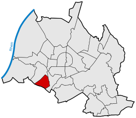
Oberreut
|
Oberreut |
||
|---|---|---|
| District of the city of Karlsruhe | ||
|
|
||
| Basic data | ||
| Geographer. location | 48 ° 59 ′ N , 8 ° 22 ′ E | |
| surface | 2.4221 km² | |
| Residents | 9,534 (as of June 30, 2014) | |
| Population density | 3,936 inhabitants per km² | |
| prefix | 0721 | |
| Transport links | ||
| tram | 1 | |
| Bus routes | 50 51 | |
| Night traffic | NL5 | |
Oberreut is a district in the south of Karlsruhe in the state of Baden-Württemberg .
The place is about 2.5 kilometers southwest of Karlsruhe city center and south of the B 10 . It has around 9,500 residents. The district can be reached via the A5. (Exit 48) or via the B10.
history
The first houses in Oberreut were moved into in the summer of 1964. The place was created according to the general development plan , also called Schneiderplan, drawn up in 1926 in the district of Bulach .
A housing estate for around 12,000 people was built on the drawing board on an area of 100 hectares. In 1970 the development of the forest area was finished. 5700 inhabitants, instead of the planned 4200, lived in the 1160 apartments. Then the field was planned.
The partial development plan "Oberreut-Feldlage I" was adopted in 1969 as a statute . 439 residential units for 1500 people were built. In 1980 the "Oberreut-Feldlage II" development plan was added. "Oberreut-Feldlage III" followed in 1990.
On June 30, 1999, 9,956 people (9,817 of them with main residence) lived in 4,231 apartments in Oberreut.
economy
- The Deutsche Bausparkasse Badenia has its headquarters in Oberreut on Badeniaplatz.
- In addition to a weekly market, there are several supermarkets
education
In addition to the Anne Frank School Community School and the Sophie Scholl Realschule, there is a glazier school and the Engelbert Bohn vocational school in this district .
Attractions
The ruins near Oberreut are located in today's Oberreuter district in the Oberreuter Forest .
Web links
- Oberreut in the Stadtwiki Karlsruhe

