
Surheide (Bremerhaven)
|
Surheide
Suurheid ( Low German ) City of Bremerhaven
Coordinates: 53 ° 31 ′ 11 " N , 8 ° 38 ′ 21" E
|
|
|---|---|
| Height : | 3 m above sea level NHN |
| Area : | 3.01 km² |
| Residents : | 2901 (December 31, 2018) |
| Population density : | 964 inhabitants / km² |
| Postal code : | 27574 |
| Area code : | 0471 |
  Location of Surheide in Bremerhaven
|
|
Surheide ( Low German Suurheid ) is a town and district in the southern district of the municipality of Bremerhaven in the German state of Bremen .
geography
The Surheide district is located in the southeast of the city and borders the Wulsdorf and Geestemünde districts in the west, the Schiffdorferdamm district in the north and the Lower Saxony communities of Schiffdorf and Loxstedt in the east and south . The height 7.5 m above sea level. NHN is reached at the school.
The Düllhamm is a 4.3 hectare nature reserve in the Surheide-Süd / Ahnthammsmoor nature reserve . To the south it borders the Bremerhaven – Buxtehude railway line .
history
.JPG)
On December 19, 1937, the foundation stone for the first 175 settlement houses in Otto Telschow City , named after Nazi Gauleiter Otto Telschow , was laid on Vieländer Weg . Schiffdorfer farmers of the Lower Saxony homestead had only sold the land under threat of expropriation. The settlers were shipyard and fishing port workers as well as seafarers, who maintained good contacts as settler communities. The Surheide settlement was part of the barracks clearance program. The first families to get a house were the large families who lived “on the Bult”. They lived behind the wire rope works, where the school and houses are now - in self-made houses. Only a dirt road led into the area. Otherwise there were gardens and meadows - a little further on was the “Imelspark” restaurant. The roads laid out in 1938 were named after rivers in Bavaria (Iller, Inn, Isar, Lech), in 1939 after places and landscapes in Austria and the Sudetenland (Egerland, Salzburg, Tyrol, Ostmark, Sudeten and Styria), which is a connection with Austria and the smashing of the rest of the Czech Republic. Other streets were named after well-known National Socialists. The school started teaching in 1940.
In 1945 the name of the settlement was changed to "Surheide". The streets named after National Socialists were also renamed: Donauplatz (formerly Platz der Alten Garde), Illerstrasse (Arthur Wiegels-Strasse [Wiegels was an SA man from the Elbmarsch]), Innstrasse ( Albert Leo Schlageter- Strasse), Isarstrasse ( Dietrich Eckart -Straße), Lechstraße ( Wilhelm Gustloff -Straße). Because of the Second World War it got stuck in its development and was almost forgotten. Until 1948, when the currency reformed, Surheide was also known in Central Germany; because here oil and fish could be exchanged for sugar, alcohol and important life goods. The expansion soon began in giant strides. The residents, appropriately organized in settler communities, have received several awards for their exemplary community work and their neat settlement in the state of Bremen and at the federal level. The Youth Red Cross received important impulses from here. Bernhard Lohmüller , Bremerhaven's first member of the Bundestag, lived in a housing estate in Surheide. The heyday of the settlement was in the 1950s and 1960s. In 1957 the Altmühlstrasse and in 1958 the Allgäuer Strasse were newly laid out. At that time Surheide had "three butchers, five shops, two hairdressers, two cobblers, two bakers, post office, savings bank, fish smokehouse, vegetable and coal trade, locksmiths, glaziers, dentists, gardeners". The Tuspo was founded in 1952, and on Dullmannsweg, today Wulsbergen, a sports facility was built in the 1950s, which was given a grass pitch in the 1980s. In 1950 the Bremerhaven Transport Company (VGB) connected the place briefly to 1951 with a bus line. The ev.-luth. Surheide Church of the Resurrection with the free-standing bell tower and its very pointed helmet was built in 1968.
In 1971 Surheide became a district through a redistribution of the districts in Bremerhaven.
Surname
Surheide is the youngest part of Bremerhaven. One possible interpretation of the place name: Sur comes from the south. The earlier field name means southern heather. Another interpretation says: Surheide comes from Low German and means "sour heather" because the field of the Schiffdorfer farmers was sour soil.
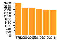
Population development
| year | Residents | source |
|---|---|---|
| 1978 | 3700 | |
| 2000 | 3156 | |
| 2005 | 3135 | |
| 2010 | 2971 | |
| 2015 | 2934 | |
| 2018 | 2901 |
|
politics
All citizens - including initiatives, groups, associations, schools, kindergartens, the parish and other institutions - can participate in the public district conference Surheide (STK) in the design of the district, and this through their spokesman for the magistrate of the seaside city of Bremerhaven and the Bremerhaven City council represented. The first district conference took place on April 14, 1994.
Economy and Infrastructure
Public facilities

- Surheid Elementary School, Isarstrasse 58
- Lücke leisure center , Carsten-Lücken-Straße 18
- Ev.-luth. Day care center Surheide, Carsten-Lücken-Straße 125
- Evangelical Lutheran Church of the Resurrection Surheide, Carsten-Lücken-Straße 127, built in 1968 by Ludwig Franzius and his son Jan Niklas Franzius
- Gymnastics and sports club Surheide from 1952 (Tuspo)
- Sports facility Wulsbergen 14
traffic
In 1955 a permanent bus connection, line H, to Surheide was set up.
Today (2019) the lines 503, 509 and 517 of the Bremerhaven Versorgungs- und Verkehrs-GmbH end in Surheide. In the weekend nights the ring line ML connects the district u. a. to the main station and the city center.
The district is located at the Bremerhaven-Geestemünde junction of the federal motorway 27 .
literature
- Rosemarie Blum: 75 years of Surheide - from the settlement to the district. Bremerhaven 2012.
Web links
- Website of the TUSPO Surheide 1952 e. V.
- Website of the Church of the Resurrection Surheide
- Internet presentation of the residential property association - Siedlergemeinschaft Surheide / Seebeck
- Surheide district history on www.bremerhaven.de
Individual evidence
- ↑ a b c Brief statistical report. (PDF; 191 kB) 4th quarter 2018. In: Website City of Bremerhaven. Magistrat Bremerhaven - Bürger- und Ordnungsamt, December 31, 2018, p. 2 , accessed on April 4, 2020 .
- ↑ Statistisches Landesamt Bremen (Ed.): Statistisches Jahrbuch 2008 . Self-published, December 2008, ISSN 0942-9883 , p. 22 , p. 2 (290 p., Digital copy [PDF; 1.8 MB ; accessed on April 4, 2020]).
- ↑ On life in the late 1950s. A housewife from Surheide reports. (No longer available online.) In: dhb-bremerhaven.de. Archived from the original on October 31, 2016 ; accessed on April 4, 2020 .
- ^ Information according to a letter to the editor from a contemporary witness . In: Nordsee-Zeitung . January 15, 2013.
- ^ A b Harry Gabcke : 150 years of Bremerhaven. 1827-1977 . Bremerhaven then and now. Ditzen & Co. Verlag, Bremerhaven 1978 (168 pages).
- ↑ a b Susanne Schwan: The settlers on the sour heath - 75 years ago today: “Primeval stones” remember the laying of the foundation stone of the “Otto-Telschow-Stadt” settlement on December 19, 1937 . In: Nordsee-Zeitung . December 19, 2012 ( digitized version ). ( Page no longer available )
- ↑ Brief statistical report. (PDF; 59 kB) September 2001. In: Website City of Bremerhaven. Bremerhaven Magistrate - Statistical Office and Electoral Office, December 31, 2000, p. 2 , accessed on April 4, 2020 .
- ↑ Brief statistical report. (PDF; 153 kB) February 2006. In: Website City of Bremerhaven. Bremerhaven Magistrate - Statistical Office and Electoral Office, December 31, 2005, p. 2 , accessed on April 4, 2020 .
- ↑ Brief statistical report. (PDF; 104 kB) October 2011. In: Website City of Bremerhaven. Magistrat Bremerhaven - Bürger- und Ordnungsamt, December 31, 2010, p. 2 , accessed on April 4, 2020 .
- ↑ Brief statistical report. (PDF; 113 kB) October 2016. In: Website City of Bremerhaven. Magistrat Bremerhaven - Bürger- und Ordnungsamt, December 31, 2015, p. 2 , accessed on April 4, 2020 .
- ^ Paul Homann: Bremerhaven's route networks (ÖPNV) since 1881. (PDF; 2.5 MB) In: Website Bremerhavenbus. P. 100, bookmark January 1, 2017 , accessed April 4, 2020 .

Northern municipality: Weddewarden (Weddewarden) | Leherheide (Königsheide, Fehrmoor, Leherheide-West) | Lehe (Speckenbüttel, Eckernfeld, Twischkamp, Goethestrasse, Klushof, Schierholz, Buschkämpen) | Center (center-south, center-north)
District South: Geestemünde (Geestemünde-Nord, Geestendorf, Geestemünde-Süd, Bürgerpark, Grünhöfe) | Schiffdorferdamm (Schiffdorferdamm) | Surheide (Surheide) | Wulsdorf (Dreibergen, Jedutenberg) | Fischereihafen (Fischereihafen, Luneplate)
City of Bremen area: City of Bremen's overseas port area