
Tanimbar Islands
| Tanimbar Islands | ||
|---|---|---|
 |
||
| Waters | Banda Lake , Arafura Lake | |
| archipelago | Moluccas | |
| Geographical location | 7 ° 30 ′ S , 131 ° 30 ′ E | |
|
||
| Main island | Yamdena | |
| Total land area | 5430 km² | |

The Indonesian archipelago of Tanimbar ( Bahasa Indonesia : kepulauan Tanimbar ) belongs to the Moluccas .
geography
overview
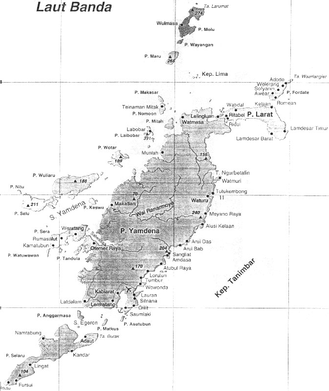
The Tanimbar Islands are about halfway between Timor and New Guinea . Neighbor to the west are the Babar Islands , to the northeast are the Aru Islands and the Kei Islands . At the same time, they form the eastern end of the Lesser Sunda Islands . The Tanimbar Islands delimit the Banda Sea in the north from the Arafura Sea in the south. Administratively, the archipelago forms the administrative district of the same name ( Kabupaten ) Tanimbar Islands of the Maluku Province .
The main island of the archipelago is Yamdena ( North Timor ; 2,981 km²), around which numerous islands are grouped to the south, west and north. To the south are Selaru ( South Timor ; 775 km²), Anggarmasa , Matkus , Nustabun , Nuyanat , Batbual and Asutubun , to the west Wuliaru ( Waliaru , Wariaru ; 220 km²), Selu (230 km²), Sera , Watuwawan , Tandula , Keswotaru. , Nuswotaru ( Wotar ) and Nitu and north of Larat (515 km²), Fordate , Laibobar , Mitah , Namoon , Makasar , the Lima Islands , Maru , Wayangan and Molu . There are also other small islands. The Egeronstraße separates Yamdena and Şelaru between Yamdena and Wuliaru is the Yamdenastraße . The total land area is 5,430 km².
The highest peak of the archipelago is on Laibobar and is 391 m high.
geology
The Tanimbar Islands are made up of tertiary layers and have numerous coral reefs , especially in the west .
fauna and Flora
Strong influences from the Australian flora and fauna can already be observed on the Tanimbar Islands . However, some species are restricted to the Tanimbar Islands. Only here, for example, is the very rare Tanimbar Barn Owl , for which no observations have been made in the field so far and which has only been scientifically described on the basis of bellows. The Goffink's cockatoo is also endemic to the islands .
population

The largest city Saumlaki , with about 10,000 inhabitants, is located on the main island of Yamdena. Saumlaki also has a small, but less frequented airport and an expanded port, which is mainly served by the state shipping company Pelni .
The traditional population is divided into four ethnic groups: Yamdena on the east coast of the island of the same name, Seluwasan on the west coast, Fordata on the north coast and the offshore islands in the north and west and Selaru on the island of the same name.
Because of unrest in Ambon , many Christians fled to Saumlaki. The population there is therefore composed of almost 100% Protestants .
Individual evidence
- ↑ Map of Maluku Tenggara Barat
- ^ Map of the Tanimbar Islands
- ^ Ethnological map of the Tanimbar Islands
- ↑ Claus König , Friedhelm Weick: Owls of the World . Christopher Helm, London 2008, ISBN 978-0-7136-6548-2 , p. 222
- ↑ Indonesia Traveling: Tanimbar ( Memento of the original from November 25, 2015 in the Internet Archive ) Info: The archive link has been inserted automatically and has not yet been checked. Please check the original and archive link according to the instructions and then remove this notice.