
Inn Valley

The Inntal is a valley that crosses the Eastern Alps from southwest to northeast and is traversed by the Inn .
It is divided into
- the Graubünden Upper Engadine and Lower Engadine
- the Tyrolean Upper Inn Valley and Lower Inn Valley (the Inn Valley in the greater Innsbruck area is sometimes referred to as the middle Inn Valley )
- the Bavarian Inn Valley .
The Bavarian Inn Valley merges into the Alpine foothills near Rosenheim . Here the Inn valley continues with little profile, and it follows
- the Lower Inn (with the Upper Austrian Inntal spatial unit ).
The Inntal of the Alps is a typical glacier trough valley with steep flanks and high shoulders and terraces, corresponding to the once mighty ice age Inn glacier . It only has the Engadine greater breakthroughs and through gorges , most recently Finstermünzer canyon Switzerland Tirol. Even after leaving the Alps in Fischbach am Inn (Tyrol-Bavaria) the Inn Valley until about Wasserburg am Inn also influenced by the Inn Glacier, here the Rosenheim basin excavated and on the edge of high moraines left behind. The Inntal of the Alpine foothills is at the beginning still a clear valley, then - from the mouth of the Salzach , as the border river Bavaria - Upper Austria - a wide basin landscape.

The Inntal from Volderberg towards Hall in Tirol and Innsbruck

The Inntal near Kufstein and Kiefersfelden with Pendling
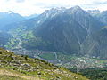
View of the Inn Valley from the Krahberg towards Landeck
View from the Seefeld plateau towards Mieming and Landeck

Inn valley near Neubeuer ( Carl Anton Joseph Rottmann , 1823)


literature
- Johann Jakob Staffler : The German Tyrol and Vorarlberg, topographical, with historical remarks , in two volumes, Volume 1: Vorarlberg, Oberinnthal and Vinschgau, Unterinnthal and Wippthal , Innsbruck 1847, 974 pages ( e-copy ).