Tisová (Nejdek)
| Tisová | ||||
|---|---|---|---|---|
|
||||
| Basic data | ||||
| State : |
|
|||
| Region : | Karlovarský kraj | |||
| District : | Karlovy Vary | |||
| Municipality : | Nejdek | |||
| Area : | 526.8465 ha | |||
| Geographic location : | 50 ° 21 ' N , 12 ° 44' E | |||
| Residents : | 131 (2011) | |||
| Postal code : | 362 21 | |||
| traffic | ||||
| Railway connection: | Karlsbad – Johanngeorgenstadt | |||
Tisová (German Eibenberg ) is a district of the municipality Nejdek ( Neudek ) in the Karlsbad district in the Czech Republic .
geography
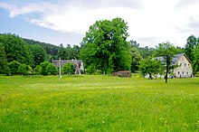
The place is about 2 km north of Nejdek in the Bohemian Ore Mountains . The highest and central point of the district is the Tisovský vrch ( Peindlberg ) with 977 m nm The settlement is on its southwest slope and extends to about 700 to 830 m nm On the eastern slope is the Seify ( Saifenhäusl ) stop .
Surname
The Czech name has been traceable since 1918 and follows a translation of yew (Czech tis). The place was called Naiabarch (New Mountain) by the inhabitants , which is an indication of the later settlement by mining in the 16th century. The Saifenhäusl settlement takes its name from tin soap mining , mainly in the Limnice ( Limnitzbach ).
history

Like many other villages around Nejdek, Eibenberg owes its existence to tin mining. From the 16th century onwards, there was lively mining on the Neuen Berg located there . In the Thirty Years War he came to a standstill. The tin mines no longer existed around 1800. The mining of iron ore continued for a long time. The Seegen Gottes Zeche was in operation until 1870.
The place Eibenberg was mentioned in 1651 in the list of souls of the Elbogen district . At that time 7 families lived there. The inhabitants were mostly wood cutters and houses. The judge's office was held by Zacharias Schaffer. The place name is derived from the yew tree that grew abundantly there. In 1654, the Berni Rula lists Eibenberg as a poor village with small fields, in which the test subjects, mainly oats, cultivated the land on barren fields. Eibenberg was parish to Neudek where the cemetery was.
In the middle of the 18th century the village consisted of 28 houses. The residents lived in great poverty. The Theresian register of 1757 reports: “ The subjects in Eibenberg are very poor. They live from felling wood and lace and often have no bread at home for 3-4 days. “In 1847 the place had 72 houses with 551 inhabitants, 1 community school and 1 tavern. Until the abolition of patrimonial jurisdiction in 1848/49, Eibenberg belonged to the Neudek rule , from 1850 to the judicial district of Neudek and since the territorial reform in 1869 to the district of Graslitz . In 1910 Eibenberg was added to the spun-off Neudek district. In the course of the annexation of the Sudetenland , Eibenberg belonged to the Neudek district between 1938 and 1945 .
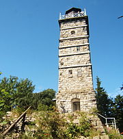
In 1896 it was connected to the Karlovy Vary – Johanngeorgenstadt railway . Saifenhäusl benefited from this above all, which became the starting point for hikes due to its proximity to the Peindlberg with its observation tower. The station was also important for the removal of the felled wood. The popular, and meanwhile burned down, “Waldesruh” restaurant was located here.
After the Second World War, a large part of the German population was expelled .
Development of the population
|
|
|
literature
- Otto Kutzer: Eibenberg with Saifenhäusl. In: Heimatbuch Landkreis Neudek. 2nd Edition. Home group Glück Auf Landkreis Neudek, Augsburg-Göggingen 1978, pp. 270–280 ( digitized version )
- Pavel Andrš, Josef Grimm (translator): Ore Mountains between Neuhammer (Nové Hamry) and Bärringen (Pernink) - Saifenhäusl (Sejfy), a popular tourist destination. In: The Border Crosser. Information from the Bohemian Ore Mountains Issue 53, September 2015, pp. 18-20 ( PDF; 4.19 MB )
Individual evidence
- ↑ Územně identifikační registr ČR
- ↑ mapy.cz
- ↑ Heimatbuch Landkreis Neudek: Published for the 10th home meeting on 16./17. September 1978 in Augsburg . Home group "Glück auf", Neudek district, 1978 ( google.de [accessed on March 31, 2020]).
- ^ Johann Gottfried Sommer: The Kingdom of Bohemia, presented in statistical topography: Bd. Elbogner Kreis. 1847 . JG Calve, 1847 ( google.de [accessed March 31, 2020]).
- ↑ Historický lexikon obcí České republiky - 1869-2015. Český statistický úřad, December 18, 2015, accessed on July 15, 2017 (Czech).


