Tokko (river)
|
Tokko Токко |
||
|
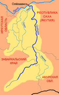
Location of the Tokko (Токко) in the catchment area of the Oljokma |
||
| Data | ||
| Water code | RU : 18030400212117200025713 | |
| location | Sakha Republic (Yakutia) ( Russia ) | |
| River system | Lena | |
| Drain over | Tschara → Oljokma → Lena → Arctic Ocean | |
| source |
Stanowoi Highlands ( Udokan Mountains ) 57 ° 12 ′ 21 ″ N , 119 ° 39 ′ 33 ″ E |
|
| Source height | approx. 1750 m | |
| muzzle |
Tschara coordinates: 59 ° 50 '54 " N , 120 ° 22' 25" E 59 ° 50 '54 " N , 120 ° 22' 25" E |
|
| Mouth height | 138 m | |
| Height difference | approx. 1612 m | |
| Bottom slope | approx. 3.6 ‰ | |
| length | 446 km | |
| Catchment area | 23,100 km² | |
| Outflow at the level at the mouth |
MQ |
220 m³ / s |
| Left tributaries | Alatkit , Kebekte , Torgo | |
| Right tributaries | Ugu , Choruoda , Tjanja | |
| Navigable | 131 km | |
The Tokko ( Yakut and Russian Токко ) is a 446 km long right tributary of the Tschara in Eastern Siberia ( Russia ).
course
The Tokko rises at an altitude of about 1750 m on the southeast side of a 2028 m high, nameless summit in the Udokan Mountains , part of the Stanovoi highlands in the south of the autonomous Republic of Sakha (Yakutia) , in the immediate vicinity of the border with the Transbaikalia region . After a few kilometers, the Tokko flows through the high mountain lake of the same name and turns in a northerly direction. Under general maintaining this flow direction of the river then flows in wide arcs predominantly upland character carrying Olyokma River-Chara plateau until he finally good 30 km southeast of situated on the right bank of Chara village Tokko opens (below) in this river.
The most important tributaries of the Tokko are from the right Ugu, Tschoruoda (length 145 km) and Tjanja (177 km; also Tjane, in Jakut Teene), from the left Alatkit, Kebekte and Torgo.
Hydrography
The catchment area of the Tokko covers 23,100 km². The annual mean flow rate is 220 m³ / s.
Near the mouth, the Tokko is over 200 meters wide and three meters deep; its flow velocity here is 0.5 m / s.
The Tokko freezes from October to May.
Economy, infrastructure and use
The lower reaches of the Tokko are navigable for 131 km from the mouth of the Tjanja tributary.
The area through which the river flows is only sparsely populated, so there is almost no infrastructure. Just under 500 people live in the entire catchment area, mostly Evenks - that is 0.02 inhabitants / km². There are no villages directly on the river. At tributary Tjanja located near the mouth of the village of the same name, on the left tributary Torgo about 30 km above the mouth not the same, now more permanently inhabited settlement Torgo . This is where the eastern access to the deposits of the coveted gemstone Charoite begins in the area of the watershed between the catchment areas of Tschara and Tokko. By 2010, the last of the 1593 inhabitants in 1989 had left the place, which became a ghost town .
Individual evidence
- ↑ a b c Article Tokko in the Great Soviet Encyclopedia (BSE) , 3rd edition 1969–1978 (Russian)
- ↑ a b Tokko in the State Water Register of the Russian Federation (Russian)
- ↑ List of Inland Waterways of the Russian Federation (confirmed by Order No. 1800 of the Government of the Russian Federation of December 19, 2002)
