Tomás Romero Pereira (District in Paraguay)
| Tomás Romero Pereira | |
|---|---|
| Basic data | |
| Country | Paraguay |
| Department | Itapua |
| surface | 607 km² |
| Residents | 34,000 |
| density | 56 inhabitants per km² |
| founding | September 22, 1983 |
| ISO 3166-2 | PY-7 |
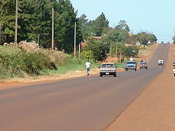
| The Ruta 6 at Maria Auxiliadora. | |
Coordinates: 26 ° 30 ′ S , 55 ° 15 ′ W
Tomás Romero Pereira , a district in the Itapúa department of Paraguay , is located about 117 km northeast of Encarnación and 163 km southwest of Ciudad del Este along the Ruta 6. The district was founded on September 22, 1983 and named after the architect and former president Tomás Romero Pereira .
Tomás Romero Pereira extends over an area of 607 km² and has around 34,000 inhabitants, 85% of whom are Paraguayans and 15% are foreigners, especially those from Brazil . The predominantly agricultural district is surrounded by the neighboring districts Natalio , Edelira , Yatytay , San Rafael del Paraná and the Caazapá department .
The urban center of the district is Maria Auxiliadora. It lies at an altitude of 345 m and is also called La Capital de la Zanahoria (Capital of the Carrot ).
Footnotes
- ↑ Dirección General de Estadística, Encuestas y Censos (DGEEC), GTZ : Itapúa. Características demográficasy socio-económicas - 2002 . Asunción 2004, p. 15.
- ↑ Dirección General de Estadística, Encuestas y Censos (DGEEC): Censo Nacional de Población y Viviendas 2002. Resultados finales and DGEEC: Anuario Estadístico del Paraguay 2009 . Asunción 2011.
