Treffurt-Wanfrieder Werratal
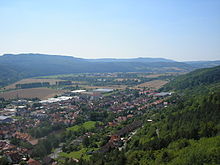
The Treffurt-Wanfrieder Werratal is the southernmost part of the Lower Werra Valley within the Lower Werrabergland natural area in the Werra-Meißner district and in the Wartburg district on the border between Hesse and Thuringia ( Germany ).
Geographical location
The section of the Treffurt-Wanfrieder Werra Valley begins southeast of Treffurt at the transition to the shell limestone heights of the Thuringian Basin and ends northwest of Wanfried at the entrance of the Werra into the Eschweger Basin . With a length of about 10 kilometers, the former inner German border crossed the river basin several times.
Natural allocation
The Treffurt-Wanfrieder Werratal is assigned as follows according to the Kassel sheet :
- (to 35 East Hessian mountains )
- (to 358 Lower Werrabergland )
- 358.1 Treffurt-Wanfrieder Werratal
- (to 358 Lower Werrabergland )
nature
The Werra emerges from the narrow breakthrough valley through the shell limestone near Falken into the landscape of the Lower Werra valley, which is mainly characterized by red sandstone . The Treffurt-Wanfrieder Werratal, about 0.5 to 2 kilometers wide, includes the flat, loess loam-covered valleys of the Werra as well as the red sandstone slopes of the adjacent mountain ranges. The floodplains are used as grassland, the slopes are used for agriculture, while the steeper slopes are already forested.
The valley is bordered by the following mountains and ridges:
- Rosoppe-Frieda-Hügelland ( Hülfensberg : 448 m) in the north
- Wanfrieder Werrahöhen ( Plesse : 480 m) in the northeast and (Muhlienberg: 447 m) in the east
- Falkener Platte ( Adolfsburg : 379 m) in the extreme southeast
- Ringgau ( Heldrastein : 504 m) in the south
- Schlierbachswald (Wiesenberg: 330 m and Asbachhöhe: 361 m) in the west
Attractions
- Old town of Wanfried
- Fachwerkstadt Treffurt
- Manor in Völkershausen
- historic half-timbered houses in Altenburschla and Heldra
Individual evidence
- ↑ Hans-Jürgen Klink: Geographical land survey: The natural space units on sheet 112 Kassel - Federal Institute for Regional Studies, Bad Godesberg 1969 → online map

