Trnávka (Ondava)
| Trnávka | ||
|
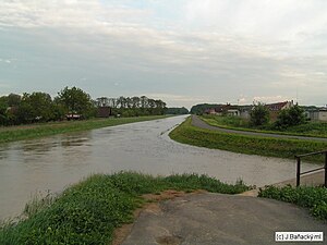
The Trnávka in Trebišov during a flood |
||
| Data | ||
| location | Slovakia | |
| River system | Danube | |
| Drain over | Ondava → Bodrog → Tisza → Danube → Black Sea | |
| source |
Slanské vrchy near Dargov 48 ° 43 ′ 50 ″ N , 21 ° 32 ′ 16 ″ E |
|
| Source height | approx. 470 m | |
| muzzle |
Ondava bei Hraň Coordinates: 48 ° 32 ′ 22 " N , 21 ° 48 ′ 12" E 48 ° 32 ′ 22 " N , 21 ° 48 ′ 12" E |
|
| Mouth height | 97 m | |
| Height difference | approx. 373 m | |
| Bottom slope | approx. 10 ‰ | |
| length | 36.6 km | |
| Left tributaries | Višňovský potok | |
| Right tributaries | Trnava, Chlmec | |
| Reservoirs flowed through | Sečovce | |
| Small towns | Sečovce , Trebišov | |
The Trnávka is a 36.6 km long river in eastern Slovakia and a tributary of the Ondava .
The river has its source in the Slanské vrchy mountains below the Ploská mountain at an altitude of approx. 470 m nm , south-southeast of the Dargov pass . It first accompanies the 1st order road 19 to the east and reaches the East Slovak lowlands in Dargov and continues through Trnávka and the Sečovce reservoir to the town of Sečovce , where the Trnávka takes up the Trnava on the right. At Hriadky the river turns south, away from the 1st order road 19 and from this point flows in the regulated river bed through Vojčice , Milhostov , the outskirts of the town of Trebišov and the municipality of Zemplínske Hradište . About a kilometer behind the latter, the largest tributary, the Chlmec, comes from the right-hand side . On the rest of the route, the Trnávka flows east and southeast and joins the Ondava east of Hraň .
Web links
- Plán manažmentu povodňového rizika v čiastkovom povodí Bodrogu (PDF, 42.9 MB, Slovak, p. 59)
