
Tupolev Tu-154M Open Skies

The Tu-154M (11 + 02) "Open Skies" was an aircraft of the flight readiness of the Ministry of Defense with special equipment for surveillance flights under the Treaty on Open Skies (English: Open Skies), the optional equipment of Dornier technically planned and largely was pre-developed.
The machine collided on September 13, 1997 over the Atlantic Ocean off Namibia with an American military transport of the Lockheed C-141 Starlifter . In the collision , all 33 occupants of both aircraft were killed.
history
A first skill was realized by 1995. In 1996 the aircraft was presented to the public at the International Aerospace Exhibition Berlin (ILA). An extension with a radar as a so-called real concept had already progressed, but was no longer implemented, since the aircraft on September 13, 1997 over the Atlantic , around 120 km west of Namibia with a Lockheed C-141 Starlifter of the US Air Force collided and got lost. The machine was outside Open Skies as a passenger plane for German participants in a regatta for the 75th anniversary of the South African Navy on the flight to Cape Town in South Africa. 24 people on board the Tupolev and 9 occupants of the American plane were killed.
As a result of the accident, the planned real concept and the equipment of the other Tu-154M (11 + 01) in the Bundeswehr's inventory no longer occurred. In addition to their actual task in the context of Open Skies, these aircraft should also take on environmental monitoring tasks. They could do flights of up to seven hours. Various other VKSE contracting states were interested in this aircraft and intended to rent it for their missions.
Background information on Open Skies
This Open Skies / Open Skies should not be confused with the term Open Skies Agreement, which is still used in civil aviation, on the freedom of movement in international air traffic.
The Open Skies described here is a result of the political initiative launched in 1966 for a conference on European security issues. After a long period of preparation, a conference on security and cooperation in Europe ( CSCE ) was held. In 1990 a treaty on the mutual limitation of conventional armed forces in Europe was concluded ( VKSE ). As a result of further negotiations, the Vienna Document on Confidence- and Security-Building Measures was drawn up and adopted in 1992. Within the scope of the sub-section "Verification from the air" negotiated therein, the Open Skies contract, which is still valid and practiced today, was concluded on March 24, 1992 with the possibility of mutual observation flights. The modalities stipulate that each of the signatory states can carry out control flights over military installations or activities (e.g. maneuvers) via a state that they wish or that they wish to observe, after brief notice. In theory, each participating state can monitor a different one, but in practice it was then about the NATO bloc and the Warsaw Pact / CIS bloc monitoring each other.
The mutual surveillance of the NATO states among one another would be politically sensitive, even if allowed under this treaty.
The performance parameters of the sensors in the aircraft are precisely defined in the Open Skies contract. The fear of espionage prevailed especially on the eastern side, so that the capabilities of the sensors were precisely defined and limited. The aircraft must first land in the country to be observed with the camera windows covered, where they are checked for compliance with the contract and must also allow external monitoring observers on board during the flight. In order to further limit the possibility of espionage, it was agreed as a principle that the state to be observed also provides the aircraft equipped with its sensors and only takes the foreign observers on board. As an alternative, however, the treaty also allows states to operate their own aircraft with their own sensors over each other's territory by bilateral agreement.
The Federal Republic of Germany took advantage of this opportunity and had signed such a bilateral agreement with a number of contracting states - some of which also did not intend to procure their own aircraft - including the states from the CIS. The equipment system in the German Open Skies Tupolew was coordinated with these countries in terms of function and performance. It was beneficial that the Federal Republic used an aircraft of eastern production, used optical sensors from Zeiss Jena known in the Eastern Bloc and for the final scope of equipment (real concept) the development and delivery of a synthetic aperture radar (SAR) in joint development of the Russian company KULON with the Dornier company ordered. This system, known as "ROSSAR", was still in development at the time of the Tupolev crash. This development was continued until the delivery and proof of functionality of the first system, but then stopped.

After the Tupolew 11 + 02 crash, the Federal Republic of Germany refrained from using its own Open Skies aircraft and sold the second remaining Tupolew Tu-154M (11 + 01).
The Federal Republic of Germany continues to participate in open skies flights / surveillance. She has the planes provided by the state under observation or rents their Saab 340 open-skies machine in Sweden .
Equipment Tu-154 Open Skies
Two aircraft Tu-154M from the Transport Air Wing 44 of the NVA came were scheduled for these tasks and should be upgraded. The plan was to convert the first aircraft into two levels of equipment, the so-called first capability, ie equipment with optical cameras and, in the second level, the real concept, with additional equipment with a radar and an infrared line scanner. Later, the second aircraft was to be converted in one phase and, depending on the availability of the sensors, also only be prepared as a replacement reserve aircraft that could be converted quickly.

Due to the takeover of Dornier by Daimler-Benz and the amalgamation with other companies to form DASA , Dornier lost industrial management of the DASA parts MBB-ERNO as general contractor and Elbe Flugzeugwerke in Dresden as equipment supplier. Dornier GmbH, which was legally independent within DASA, and Dornier Luftfahrt GmbH, which at that time still belonged to Dornier, remained responsible for the development, delivery and electronic integration of the equipment package, including the development of the sensor management system, the mission reference system, the data storage system and the electrical one System, the mission planning systems on board and on the ground as well as the digital on-board communication system and the operator workstations. The federal government provided the actual sensors such as the various cameras itself.
The development of the radar at the Russian company Kulon with Dornier as a partner for data processing was carried out in a separate order, he also had the political goal of beginning a know-how transfer with the new Russian state and a relationship of trust in economic cooperation to promote.
Elbe Flugzeugwerke carried out the modifications to the aircraft under the design responsibility and with the assistance of the aircraft manufacturer Tupolew, installed the Open Skies equipment and took over the flight tests and certification, which, however, took place at DASA / MBB in Manching. The handover to the Air Force took place on April 19, 1995. The first test flights over the territories of other countries were also carried out until the crash.
Part of the scope of equipment was a stationary mission planning system to be supplied by Dornier for the planning of the mission and the creation of maps and receipts. The system in the aircraft worked on the same principle, but only displayed the results on the screens of the operator stations and the on-board printers.
In detail, the Tu-154 M (11 + 02) was or should be scaffolded:
First skill
- 3 aerial photo measuring cameras LMK-2015 (1 × nadir , 2 × oblique) with special filter insert (to reduce the resolution) and stabilized suspension SM-2000 for the nadir camera from Carl Zeiss Jena, focal length 152 mm, image format 228 × 228 mm. Angle of view (FOV) per camera 90 °, resolution limited to 30 cm by contract, for the task of photogrammetry in nadir and side view and for recognition, identification and calibration.
- 3 VOS-60 video cameras (1 × nadir, 2 × oblique) from Zeiss, Oberkochen with 6000 pixels, FOV 60 °. Primary sensor for low altitude to discover, observe in real time, as evaluation support and as viewfinder for the cameras. The data from these sensors could be recorded on digital tape machines.
- 1 sensor management system (SMS) from IGI mbH, Hilchenbach (now Kreuztal), for controlling the remote sensing sensors LMK-2015 and VOS-60 according to the flight plan transmitted.
- 4 workstations in the cabin of the aircraft for operations management, for left, right and nadir sensors, developed and supplied by Dornier Luftfahrt GmbH. For the operations management to plan the mission and save the data / results and for the sensors to operate and observe on monitors.
- Up to 30 seats of the original seating remained in the aircraft for additional on-board observers, foreign inspectors and the transport of passengers as a secondary task. A small conference compartment was used for preliminary evaluations and discussions.
- In the underside of the fuselage of the aircraft, optically clean sanded and pressure-tight windows with covers for the cameras were installed when not in use. The devices in the hold were accessible during the flight through a hatch in the floor of the cabin.
In addition, the real concept should be built in
- A panoramic camera A-84 from ZENIT, Krasnogorsk, Russia with a focal length of 300 mm, image size 118 × 748 mm, FOV 20 ° × 143 °, resolution contractually limited to 30 cm, with automatic exposure setting and rotating lens. As a supplement to the line scanner and for discovering and mapping.
- an operating and control computer from IGI mbH, Hilchenbach (now Kreuztal) for the ZENIT A-84 panorama camera.
- a synthetic aperture radar ROSSAR (HW) from Kulon from Russia and SAR Processing (SW) from Dornier, as a sensor with a long range with bad weather and night vision capability for discovering infrastructure and systems. Permissible strip width 25 km, inclined distance 50 km. Resolution 3 m.
- an altitude measuring radar to determine the flight altitude above ground in order to be able to calculate the FMC values (Forward Motion Compensation) required for the LMKs.
- two infrared line scanners AN / AAD-5 from Pacific Sierra Research in USA, with FOV each 60 °, resolution contractually limited to 50 cm, modified for magnetic tape recording. Thermal sensor in the nadir with night and haze capability for discovery and to complement cameras. Optimized for small v / h values and a large field of view.
- a sensor management system upgrade (SMS-1) from IGI mbH, Hilchenbach (now Kreuztal) as an extension of the existing sensor management system (SMS) from the first capability to operate 1 × A-84, 3 × LMK-2015, 3 × VOS-60, 2 × AN / AAD-5, 1 × ROSSAR and 1 × height measuring radar.
- a workstation in the cabin of the Dornier Luftfahrt GmbH aircraft for the operation and display of the above-mentioned IRLS and SAR systems.
- The antenna of the SAR was to be placed in a canoe-shaped radome outside under the fuselage of the aircraft behind the camera windows; the associated radar devices were provided in racks in the lower cargo area near the cameras.
photos

Instrument panel cockpit

Lateral workplace of the flight engineer in the cockpit

Lateral workplace of the radio operator / navigator in the cockpit
Mission planning system in the stern

Operator station for cameras on the left

Operator station for cameras on the right-hand side, identical to the operator station for central cameras.

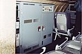
Operations management station
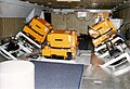
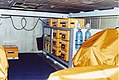
Three LMK cameras and two of the three VOS cameras in the cargo hold (accessible in flight)
MA-2000 film cassette, case for lens support and nine filter cassettes

Optical windows for the cameras in the fuselage
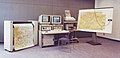
Mission planning facility on the ground in Germany

NADIR image


swell
- Brochure Daimler-Benz Aerospace / Dornier P 961 880 01 Z3, 05.96
- Brochure "Open Skies, GERMAN OBSERVATION SYSTEM" of the FEDERAL ARMED FORCES VERIFICATION CENTER, 52503 Geilenkirchen
- PETRIE, G. & H. Spitzer (2007): Open Skies: Aerial Observation to Help Prevent Conflicts Between Countries, GeoInformatics 10 (2007) 5: 24-29