
Twillbäke
|
Twillbäke (also called Säckriede / Sackriede, Sillenbäke and Schaarenbäke) |
||
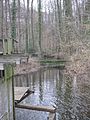
 The Hubertusmühle at the Twillbäke in Siedenbögen |
||
| Data | ||
| location | Visbek municipality , Vechta district , Lower Saxony | |
| River system | Weser | |
| Drain over | Aue → Hunte → Weser → North Sea | |
| source | east of Bonrechttern 52 ° 49 ′ 27 ″ N , 8 ° 22 ′ 57 ″ E |
|
| Source height | 48 m | |
| muzzle | Coordinates in the floodplain : 52 ° 52 ′ 34 " N , 8 ° 17 ′ 44" E 52 ° 52 ′ 34 " N , 8 ° 17 ′ 44" E |
|
| Mouth height | 28 m | |
| Height difference | 20 m | |
| Bottom slope | 1.2 ‰ | |
| length | 16.2 km | |
| Catchment area | 36 km² | |
| Left tributaries | Visbeker Bruchbach | |
| Right tributaries | Langenesch | |
The Twillbäke is an approximately 16 kilometer long loess-clay-shaped lowland stream in the municipality of Visbek in the Lower Saxony district of Vechta .
Geography and appearance
The Twillbäke rises from a drainage ditch on the eastern outskirts of the Visbeker peasantry Bonrechtern . This watercourse is called the Säckriede or Sackriede . The Säckriede first flows in southsouthwest direction crosses the west of the Schlatts Tevenpott preferred flood area , and further flows along the north-west edge of the forest area Herrenholz . In this area the Säckriede flows parallel to the Weser-Ems watershed running southeast through the Herrenholz . At the level of the Großes Kehnmoor corridor, the stream, called Sillenbäke from there, turns sharply north-northwest towards the Wöstendöllen farmers . From Wöstendöllen to the mouth, the water is called Twillbäke. The Twillbäke continues on its way in a northerly direction through the nature reserve Bäken der Endeler and Holzhauser Heide . A section of the middle course, from the hamlet of Varnhusen to Varnhorn , is also called Schaarenbäke . Over the pond of water mill Hubertusmühle in Siedenbögen the Twillbäke the east from flowing Hohenbögener corridor Langeheide coming watercourse Long Esch to. Between the Hubertusmühle and the (former watermill) Bullmühle in Varnhorn , the Twillbäke in the Schillmühle area takes in the Visbeker Bruchbach , which is also called the Visbeker Bäke, flowing from the southwest from the town of Visbek . The Twillbäke flows into the floodplain at a height of 28 m above sea level , immediately southwest of the ford there . The floodplain itself, which forms the northern border of the municipality of Visbek and the district of Vechta to the municipality of Großenkneten and the district of Oldenburg , flows south of Dötlingen into the Hunte .
Two fish farms are located at Twillbäke, a fish farm with a restaurant in Siedenbögen and a trout farm with a smokehouse in Endel .
From Wöstendöllen to the estuary, the Twillbäke is part of the Bäken nature reserve of the Endeler and Holzhauser Heide. From Varnhusen the stream flows through semi-natural deciduous and alluvial forests , the course of the Twillbäke is meandering to meandering here .
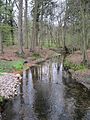
The Twillbäke below the Hubertusmühle
The Twillbäke above the Bullmühle pond

Weir at the Bullmühle in Varnhorn
Bridge at the Bullmühle weir

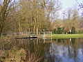
Mill pond at the Bullmühle

Meadow landscape in the nature reserve


Individual evidence
- ↑ NLWKN state database. WK25061 Twillbäke . Retrieved August 1, 2016.
Web links
- Navigator - more interactive focused on the twillbäke. Official map service of the LGLN
- Nature reserve "Bäken der Endeler und Holzhauser Heide" at the Lower Saxony State Office for Water Management, Coastal Protection and Nature Conservation