
Endel (Visbek)
|
Endel
Visbek municipality
Coordinates: 52 ° 51 ′ 46 ″ N , 8 ° 16 ′ 11 ″ E
|
|
|---|---|
| Height : | 48 m above sea level NHN |
| Residents : | 260 (Feb 19, 2020) |
| Postal code : | 49429 |
| Area code : | 04445 |

Endel is a peasantry in the northwest of the town of Visbek in South Oldenburg region district of Vechta in Lower Saxony .
Endel is on the L 880 state road , around four kilometers northwest of the Visbeck town center. The A1 runs northwest about two kilometers away. The loess-loam-shaped lowland stream Twillbäke , a tributary of the floodplain , forms the eastern boundary of the town, while the floodplain itself essentially defines the north and west boundaries of the farmers. The southeastern border finally follows a connecting line from Gut Stüvenmühle to Twillbäke at the level of the corridor near Reckenmühle , about five hundred meters below the Bullmühle. The flat, undulating topography of the peasantry is characterized by heather and floodplain landscapes and moves at heights of around 40 to 50 m above sea level. NHN , the core of the place itself near the Marien-Chapel is at an altitude of approx. 48 m above sea level. NHN , while the lowest point in the extreme northeast of the peasantry at the confluence of the Twillbäke in the floodplain at a height of about 28 m above sea level. NHN lies.
The Endeler local coat of arms shows a picture of the megalithic tomb " Heide sacrificial table ."
A regional specialty from Endel is the traditional black bread, similar to Pumpernickel , that has been baked in the Stüvenmühle according to the original recipe for over five hundred years. On the lower reaches of the Twillbäke there is a trout farm with a smokehouse.
On part of the farmers there is part of the nature reserve " Bäken der Endeler and Holzhauser Heide ", through which the floodplain and the Twillbäke flow.
Management of the peasantry
Endeler district chairman is Franz Zurwellen (as of February 19, 2020).
Attractions
- The Catholic Marienkapelle is a half-timbered building with a roof turret and oval windows. The peasant chapel is low inside and covered with beams; its foundation is traced back to the Middle Ages. In the 30-year war it was heavily damaged but rebuilt again in the 1694th In 1830 the chapel was dilapidated and should be demolished. This did not happen and a makeshift restoration took place. The chapel was thoroughly rebuilt in 1883/84, and it was finally restored to its present form in 1965. The church has 50 seats and a bronze bell.
- The two watermills Kokenmühle and Neumühle are on the Lower Saxony Mill Road .
- The well-known megalithic megalithic stone graves " Visbeker Bräutigam " and " Heidenoffertisch " in Engelmannsbäke come from the Neolithic " funnel cup culture " (3400–2800 BC).
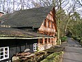
The "coke mill" in Endel
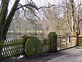
Pond at the "Kokenmühle"

Sawmill at the "Kokenmühle"
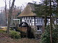
The "Neumühle" in Endel

Pond landscape at the "Neumühle"

The "Stüvenmühle" in Endel

Pond landscape at the "Stüvenmühle"

“Visbeker Groom” in Engelmannsbäke


Web links
- The Endel farmers on the website of the municipality of Visbek
- Navigator - interactive focused on the Endel farmers. Official map service of the LGLN
Individual evidence
- ↑ Landkarte Ortschaftsgrenzen_50000.pdf, publisher: Municipality of Visbek, Office for Building, Planning and Environmental Matters, Rathausplatz 1, 49429 Visbek
- ^ German society for mill knowledge and mill maintenance (DGM) eV: Stüvenmühle
- ↑ Nature reserve Bäken der Endeler and Holzhauser Heide at the Lower Saxony State Office for Water Management, Coastal Protection and Nature Conservation
- ↑ https://www.visbek.de/gemeinde Visbek, The community, farmers, district leaders
- ↑ ENDEL Gem. Visbeck, Kr.Vechta. Catholic chapel ad B. Mariam Virginem. In: Georg Dehio : Handbook of German Art Monuments . Bremen Lower Saxony. Deutscher Kunstverlag, Munich / Berlin 1992, ISBN 3-422-03022-0 , p. 447 f.
- ↑ Library of Princeton University The Architectural and Art Monuments of the Duchy of Oldenburg, 1896/1900, Volume II, Amt Vechta, pp. 376/196 /, Grand Ducal State Ministry, accessed on February 12, 2020.
- ↑ Municipality of Visbek, Tourism & Leisure, Sights, Endel Chapel ( Memento of the original dated December 7, 2013 in the Internet Archive ) Info: The archive link has been inserted automatically and has not yet been checked. Please check the original and archive link according to the instructions and then remove this notice.
- ↑ Willi Baumann and Peter Sieve on behalf of the Bischöflich Münsterschen Officialate (eds.): The Catholic Church in the Oldenburger Land . A manual. Commissioned by Plaggenborg Verlag, Vechta 1995, p. 645 f .
- ↑ Visbek coke mill
- ^ "Neumühle" Visbek
- ↑ Niedersächsische Mühlenstraße - Vechta district , accessed on October 21, 2012

Astrup | Receipt rights | Endel | Erlte | Hagstedt | Halter / Meyerhöfen | Hogen bows | North Döllen | Right field | Varnhorn / Siedenbögen | Visbek | Wöstendöllen