
Ual da Mulin
|
Ual da Mulin Val da Mulin (Laaxertobel), Ual de Mulin, Val Vau, Ual da Draus, Ual Ault |
||
 Ual da Mulin in the Laaxer Tobel |
||
| Data | ||
| Water code | CH : 351 | |
| location | Canton of Graubünden ; Switzerland | |
| River system | Rhine | |
| Drain over | Vorderrhein → Rhine → North Sea | |
| confluence | from Ual Draus and Val Buglina near Lagenberg Castle 46 ° 48 ′ 58 ″ N , 9 ° 15 ′ 57 ″ E |
|
| Source height | approx. 1040 m | |
| muzzle | opposite Valendas in the Vorderrhein Coordinates: 46 ° 47 ′ 32 " N , 9 ° 16 ′ 29" E ; CH1903: 740 174 / 183976 46 ° 47 '32 " N , 9 ° 16' 29" O |
|
| Mouth height | approx. 656 m | |
| Height difference | approx. 384 m | |
| Bottom slope | approx. 11% | |
| length | 3.4 km (with Ual Draus 13 km) | |
The Ual da Mulin (German: Mühlenbach ) is the section of the river following the Ual Draus and at the same time the tributary of the Vorderrhein in the Surselva in the Swiss canton of Graubünden . It directs the water from the region of the municipality of Laax into the Rhine at the level of the Valendas-Sagogn station of the Rhaetian Railway . It is not uncommon in the region for the name of a river to change along with the characteristics of the surroundings . The name Ual da Mulin occurs several times in the region, the closest river of this name is in Val da Siat , almost 7 kilometers to the west.
Ual da Mulin
The Ual da Mulin flows in the beginning of the Rheinschlucht in the Rhein and passes through the last few kilometers the ravine Val da Mulin with its to 200 m high steep walls, consisting of the same material of the Flimser landslide exist, such as the Rheinschlucht itself. The ravine divides the village of Laax from today's tourist quarter of Salums, where meadows and pastures used to form a forest clearing. At the river crossing at the level of the Laax Marcau postbus stop, there used to be the larger of the two Laax mills and a sawmill up to Hurricane Vivian .
power plant
Since 1961, the water in Mulania (at the junction to Murschetg ) has been held back in the small Ual da Mulin reservoir owned by the Flims power station. From there, the water from the 26 km² catchment area of the Vorab glacier is turbine via a slope pipe to Salums and through a pressure pipe down into the Rhine gorge in the Bargau power station .
Ual there
A central part of the water body is called Ual da Draus and flows over the Plaun plain (Romanesque for plain) and through the Val Plaun and Val Vau . In these areas after the plain, most of the water already flows through the rubble of the Flims landslide. There is only a short narrow gap in the Val Vau where you can reach the rock.
Ual Ault
From the Vorabgletscher and Laaxer Stöckli / La Siala areas, a water named Ual Ault (ault = high, above) strives towards Plaun. One arm from the La Siala area has a river bifurcation . The water can reach Plaun via Alp Sogn Martin or through Val da Dumengias (Romanesque "Sonntagstal").
gallery
Ual da Draus in Val Vau (middle part of the river) seen from Runca Sura to the west.
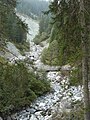
Ual da Draus at the Val Vau bridge up towards the Val Plaun.


Individual evidence
- ↑ a b individual records on the geoserver of the Swiss federal administration
- ↑ Kraftwerk Bargaus on the Flims Electric homepage ( Memento of the original from August 29, 2015 in the Internet Archive ) Info: The archive link has been inserted automatically and has not yet been checked. Please check the original and archive link according to the instructions and then remove this notice.