
Úpa
|
Úpa German Aupa |
||
 The Úpa near Ratibořice (Ratoborschitz) |
||
| Data | ||
| Water code | CZ : 1-01-02-001 | |
| location | Královéhradecký kraj , Czech Republic | |
| River system | Elbe | |
| Drain over | Elbe → North Sea | |
| origin |
Koppenplan 50 ° 44 ′ 14 ″ N , 15 ° 42 ′ 43 ″ O |
|
| Source height | 1420 m | |
| muzzle | At Jaroměř in the Elbe coordinates: 50 ° 21 ′ 13 ″ N , 15 ° 55 ′ 51 ″ E 50 ° 21 ′ 13 ″ N , 15 ° 55 ′ 51 ″ E |
|
| Mouth height | 250 m | |
| Height difference | 1170 m | |
| Bottom slope | 15 ‰ | |
| length | 77 km | |
| Left tributaries | Rudný potok, Malá Úpa , Lysečinský potok, Babský potok, Ličná, Rtyňka, Olešnice | |
| Right tributaries | Modrý potok, Zelený potok, Maršovka, Válovický potok | |
The Úpa (German: Aupa ) is a left tributary of the Elbe in the Czech Republic .
Location and course

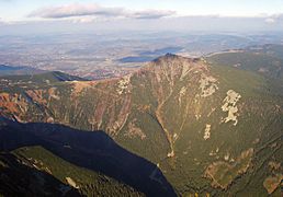
The Upa rises in the Giant Mountains west of the Snow Mountain (Pol. Śnieżka , tschech. Sněžka ) on a water-rich plateau, the couplers plan (tschech. Równia pod Śnieżką), at the boundary between the Czech Republic and Poland .
Over the Aupa falls ( Horní / Dolní Úpský vodopád ) it falls into the Giant Valley (Obří důl) and flows as the Great Aupa (Velka Úpa) in a southerly direction through the places Pec pod Sněžkou (Petzer) and Velká Úpa (Groß Aupa) .
Its first major tributary, the Kleine Aupa , comes from the Kammsteig on Schmiedeberger and Forstkamm and both unite near the “Kreuzschänke” (Restaurace na Křižovatce) in Dunkelthal (Temný Důl) , a district of Horní Maršov ( Marsh Village ) , around from there to flow further than Aupa and to cut through the ridge Dlouhý hřeben before the river leaves the actual Giant Mountains.
The closest places on the river are Horní Maršov and Svoboda nad Úpou (Freedom on the Aupa) , where the Aupatail separates the Giant Mountains from the Rehorn Mountains ( Rýchory ). At Mladé Buky (Jungbuch) the river flowing to the southeast leaves the area of the Giant Mountains National Park (KRNAP).
South of Trutnov (Trautenau) , the Aupa takes the path northeast for a few kilometers, to flow again in a south-easterly direction at the Trautenau district Poříčí (Parschnitz) in the next longitudinal valley, where the former German-speaking area is left.
Flowing through the Adamovo údoli (Adamstal), the Aupa reaches the town of Úpice (Eipel) , where the river and town names are obviously related.
A nature reserve with several bends in the river begins here . Above this romantic river valley there are several castles and chateaus, including Ratibořice Castle . The valley is called Babiččino údolí (Grandmother's Valley) in memory of the Czech writer Božena Němcová , who spent her childhood here and later described it in her work “ Babička ” (The Grandmother) . At the Zlíč weir (opposite the Ratibořice castle), the Úpský přivaděč is diverted to the Rozkoš reservoir , with the underwater being diverted into the Mettau via the Rozkoš brook .
Shortly before the town of Česká Skalice (Bohemian Skalitz) the nature reserve ends and the Aupa changes direction again, this time to the southwest, to finally flow unspectacularly into the Elbe after 77 km in the town of Jaroměř (in the Jacobi-Vorstadt district) .
gallery
The huge reason

Torrent control near Trautenau

In the Großmuttertal

Winter in Jaroměř

muzzle


.jpg)


Footnotes
- ↑ German Scientific and Medical Association for Bohemia "Lotos" (Ed.): Lotos . Prague 1919 ( limited preview in Google Book Search).
- ↑ Havlovice - Náchodec. Havlovice, accessed on October 21, 2018 (cz).
- ^ Albrecht Greule : German book of water names: Etymology of water names and the associated area, settlement and field names . De Gruyter, Berlin 2014, ISBN 978-3-11-033859-1 , p. 46 ( limited preview in Google Book search).