
Urff
| Urff | ||
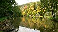
 The Urff near Oberurff-Schiffelborn |
||
| Data | ||
| Water code | DE : 42886 | |
| location | Schwalm-Eder district and Waldeck-Frankenberg district ; North Hesse ( Germany ) | |
| River system | Weser | |
| Drain over | Schwalm → Eder → Fulda → Weser → North Sea | |
| source | in the Kellerwald near Großer Aschkoppe 51 ° 4 ′ 32 ″ N , 9 ° 0 ′ 46 ″ E |
|
| Source height | approx. 564 m | |
| muzzle | in Löwensteiner Grund near Niederurff Coordinates: 51 ° 2 ′ 13 ″ N , 9 ° 12 ′ 19 ″ E 51 ° 2 ′ 13 ″ N , 9 ° 12 ′ 19 ″ E |
|
| Mouth height | approx. 193.5 m | |
| Height difference | approx. 370.5 m | |
| Bottom slope | approx. 18 ‰ | |
| length | 20.1 km | |
| Catchment area | 41.74 km² | |
| Drain |
MQ |
495 l / s |
| Communities | Armsfeld , Hundsdorf , Oberurff-Schiffelborn , Niederurff | |
The Urff is a 20.1 km long, western and left tributary of the Schwalm in the district of Waldeck-Frankenberg and Schwalm-Eder district , northern Hesse ( Germany ).
course
The Urff rises in the Kellerwald . Its source is located west-southwest of the Hundsdorf district of Bad Wildung and east-northeast of the Haina district of Löhlbach on the transition area between Großer Aschkoppe ( 639.8 m ) in the southeast, Alter Koppe ( 591.4 m ) in the southwest and Wölftekopf ( 567.1 m ) in the north-northeast . A few meters northwest past the above the Ritterwiese at about 564 m above sea level. The source lying on the NHN runs between Löhlbach and Hundsdorf on federal road 253 .
The Urff, which flows around the Great Aschkoppe on its north, north-east and east flanks, runs through the wooded Kellerwald-Edersee Nature Park in an initially eastward direction to and through Hundsdorf, where it bends to the south-east towards Armsfeld . Below Armsfeld, south of Auenbergs ( 610.7 m ), turns the creek to the east and flows past the village Fischbach and Bergfreiheit , the castle ruins Lowenstein ( 341.2 m ) passing, and Oberurff-Schiffelborn after Niederurff .
The confluence of the Urff in the Schwalm is in the Löwensteiner Grund below and east of Niederurff at a height of about 193.5 m ; to the northeast opposite rises the Altenburg ( 432.7 m ).

View from the Löwenstein castle ruins to the Urff valley in the Kellerwald
One of the Urff fish ponds between Berg Freiheit and Oberurff

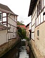
Leisure and fishing pond fed by the Urff near Oberurff-Schiffelborn
Flow from Oberurff


Catchment area and tributaries
The Urff is a body of water III. Order . Its catchment area covers 41.74 km².
The tributaries of the Urff include, among others ( viewed downstream ):
- Heerbach (on the right; confluence between Hundsdorf and Armsfeld)
- Appenbach (on the right; confluence between Armsfeld and Berg Freiheit)
- Kohlbach (on the left; confluence between Armsfeld and Berg Freiheit)
Localities

The villages on the Urff are ( viewed downstream ):
- Bad Wildungen -Hundsdorf
- Bad Wildungen-Armsfeld
- Bad Wildungen- Berg Freiheit
- Bad Zwesten - Oberurff-Schiffelborn
- Bad Zwesten-Niederurff