Vallières (Haute-Savoie)
| Vallières | ||
|---|---|---|
|
|
||
| local community | Vallières-sur-Fier | |
| region | Auvergne-Rhône-Alpes | |
| Department | Haute-Savoie | |
| Arrondissement | Annecy | |
| Coordinates | 45 ° 54 ' N , 5 ° 56' E | |
| Post Code | 74150 | |
| Former INSEE code | 74289 | |
| Incorporation | 1st January 2019 | |
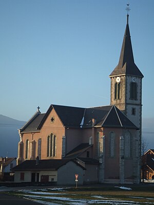
 Church Saint-François-de-Sales |
||
Vallières is a village and a former French commune with last 1,807 inhabitants (2016) in the department of Haute-Savoie in the region of Auvergne Rhône-Alpes .
With effect from January 1, 2019, the former municipalities of Vallières and Val-de-Fier were merged to form the Commune nouvelle Vallières-sur-Fier . The former municipalities were not granted the status of a Commune déléguée in the new municipality . The administrative headquarters are in Vallières.
geography
Vallières is located at 346 m , near Rumilly , about 15 km west of the city of Annecy (as the crow flies). The village extends in the Albanais , slightly elevated on the edge of the wide valley of the Fier , east of the ridge of the Montagne du Gros Foug.
The area covers a section of the western Genevois . The southern border runs along the Fier, which flows in an arc around the Vallières plateau. The Morge flows below the village and forms the western boundary of the area. From the course of the Fier river, the area extends north-east to the adjacent slopes. Above the Château de Chitry, the highest point in Vallières is reached at 510 m .
In addition to the actual town center, Vallières also includes various hamlet settlements and farms, including:
- Verlioz ( 375 m ) in the valley of the Fier east of Vallières
- Burnel ( 410 m ) on the plateau between Fier and Morge
- Jussy ( 420 m ) on the northern slope of the Fier
- Chitry ( 449 m ) on the northern slope of the Fier
Neighboring towns of Vallières are Saint-Eusèbe in the north, Hauteville-sur-Fier and Sales in the east, Rumilly in the south and Moye , Lornay , Val-de-Fier and Versonnex in the west.
history
The area of Vallières was already settled during Roman times.
In 1880, numerous houses fell victim to a village fire.
Attractions
The village church of Saint-François-de-Sales was built in 1877 in the neo-Gothic style. Of the secular buildings in the area around Vallières, the Château de Chitry (originally from the 15th century), other mansions in Morgenex and Vallières, and the mill on the Morge should be mentioned. The Pont de Coppet over the Fier was inaugurated in 1626.
population
| Population development | |
|---|---|
| year | Residents |
| 1962 | 568 |
| 1968 | 673 |
| 1975 | 758 |
| 1982 | 921 |
| 1990 | 1,046 |
| 1999 | 1,277 |
| 2004 | 1,359 |
Vallières was one of the smaller communities in the Haute-Savoie department. A significant increase in population has been recorded since the early 1960s. Numerous single-family houses were built outside the old town center.
Economy and Infrastructure
Vallières was a predominantly agricultural village well into the 20th century . Today there are various small and medium-sized businesses. Many workers are also commuters who work in the larger towns in the vicinity and in the Annecy area.
The village is very well developed in terms of traffic. It is on a departmental road that leads from Rumilly to Frangy . Further regional road connections exist with Seyssel and Annecy. The closest connection to the A41 motorway is around 12 km away.
