Vendée (river)
| Vendée | ||
|
The Vendée in Fontenay-le-Comte |
||
| Data | ||
| Water code | FR : N --- 0120 | |
| location | France , Pays de la Loire and Nouvelle-Aquitaine regions | |
| River system | Sèvre Niortaise | |
| Drain over | Sèvre Niortaise → Atlantic Ocean | |
| source | on the municipal boundary of L'Absie and Saint-Paul-en-Gâtine 46 ° 37 ′ 47 ″ N , 0 ° 35 ′ 0 ″ W |
|
| Source height | approx. 210 m | |
| muzzle | on the municipal boundary of L'Île-d'Elle and Marans in the Sèvre Niortaise Coordinates: 46 ° 19 ′ 22 ″ N , 0 ° 57 ′ 47 ″ W 46 ° 19 ′ 22 ″ N , 0 ° 57 ′ 47 ″ W |
|
| Mouth height | approx. 2 m | |
| Height difference | approx. 208 m | |
| Bottom slope | approx. 2.5 ‰ | |
| length | 82 km | |
| Right tributaries | Mère | |
| Reservoirs flowed through | Barrage d'Albert, Barrage de Mervent | |
| Small towns | Fontenay-le-Comte | |
|
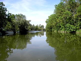
The river just before the mouth |
||
The Vendée is a river in France that runs through the Pays de la Loire and Nouvelle-Aquitaine regions. It rises on the municipal boundary of L'Absie and Saint-Paul-en-Gâtine , generally drains to the southwest, passes through two reservoirs above Fontenay-le-Comte and flows 82 kilometers into the municipal boundary of L'Île-d'Elle and Marans , in the Marais Poitevin , as a right tributary to the Sèvre Niortaise . On its way, the Vendée crosses the Deux-Sèvres and Vendée departments and forms the border with Charente-Maritime for the last few kilometers .
Places on the river
- Saint-Paul-en-Gâtine
- La Chapelle-aux-Lys
- Saint-Hilaire-de-Voust
- Saint-Michel-le-Cloucq
- Fontenay-le-Comte
- Le Poiré-sur-Velluire
- Le Gué-de-Velluire
- L'Île-d'Elle
shipping
The river was channeled between the estuary and Fontenay-le-Comte in the 19th century and opened to navigation. The locks of Le Gouffre (at the mouth) and Longèves overcame the slight difference in altitude. Shipping ceased in 1965. The Le Gouffre lock can still be seen today.
Web links
Individual evidence
- ↑ Source geoportail.gouv.fr
- ↑ estuary geoportail.gouv.fr
- ↑ a b The information on the length of the river is based on the information on the Vendée from SANDRE (French), accessed on April 11, 2013, rounded to full kilometers.
- ^ Entry on the Vendée in the Babel project

