
L'Absie
| L'Absie | ||
|---|---|---|

|
|
|
| region | Nouvelle-Aquitaine | |
| Department | Deux-Sèvres | |
| Arrondissement | Parthenay | |
| Canton | Cerizay | |
| Community association | Bocage Bressuirais | |
| Coordinates | 46 ° 38 ′ N , 0 ° 35 ′ W | |
| height | 168-256 m | |
| surface | 13.02 km 2 | |
| Residents | 979 (January 1, 2017) | |
| Population density | 75 inhabitants / km 2 | |
| Post Code | 79240 | |
| INSEE code | 79001 | |
| Website | http://www.absie.fr/ | |
 Town hall (Mairie) by L'Absie |
||

L'Absie is a commune with 979 inhabitants (as of January 1 2017) in Deux-Sevres in the region Nouvelle-Aquitaine . It belongs to the Parthenay arrondissement and the Cerizay canton (until 2015: Moncoutant canton ). The inhabitants are called Absiens .
geography
L'Absie is about 24 kilometers west of Parthenay and about 24 kilometers south-southwest of Bressuire . The Vendée rises in the municipality . L'Absie is surrounded by the neighboring communities of La Chapelle-Saint-Étienne in the north and north-west, Largeasse in the north-east, Vernoux-en-Gâtine in the east and south-east, Scillé in the south and Saint-Paul-en-Gâtine in the west.
Population development
| year | 1962 | 1968 | 1975 | 1982 | 1990 | 1999 | 2006 | 2013 |
| Residents | 1325 | 1331 | 1371 | 1342 | 1255 | 1096 | 1012 | 979 |
| Source: Cassini and INSEE | ||||||||
Attractions
- Notre-Dame monastery church, monument historique since 1932
- Abiès Park
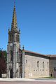
Notre-Dame monastery church

Abiès Park


Web links
Commons : L'Absie - collection of images, videos and audio files