
Louin
| Louin | ||
|---|---|---|
|
||
| region | Nouvelle-Aquitaine | |
| Department | Deux-Sèvres | |
| Arrondissement | Parthenay | |
| Canton | Le Val de Thouet | |
| Community association | Airvaudais-Val du Thouet | |
| Coordinates | 46 ° 48 ′ N , 0 ° 10 ′ W | |
| height | 73-160 m | |
| surface | 20.56 km 2 | |
| Residents | 684 (January 1, 2017) | |
| Population density | 33 inhabitants / km 2 | |
| Post Code | 79600 | |
| INSEE code | 79156 | |

Louin is a western French community with 684 inhabitants (at January 1, 2017) in the department of Deux-Sèvres in the region Nouvelle-Aquitaine . The municipality belongs to the Arrondissement Parthenay and the canton Le Val de Thouet (until 2015: canton Saint-Loup-Lamairé ).
location
Louin is located about 25 kilometers east-southeast of Bressuire and about 18 kilometers north-northeast of Parthenay am Thouet . Louin is surrounded by the neighboring communities of Tessonnière in the north, Airvault in the northeast, Saint-Loup-Lamairé in the east and southeast, Gourgé in the south, Lageon in the south and southwest and Maisontiers in the west.
Population development
| year | 1962 | 1968 | 1975 | 1982 | 1990 | 1999 | 2006 | 2013 |
| Residents | 830 | 805 | 767 | 800 | 795 | 751 | 735 | 717 |
| Source: Cassini and INSEE | ||||||||
Attractions
- Gallo-Roman hypogeum , Monument historique since 1916
- Saint Martin Church
- Grand Cross in the cemetery, Monument historique since 1890
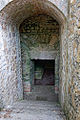
Hypogeum

Grand Cross


Web links
Commons : Louin - collection of images, videos and audio files