
Saint-Michel-le-Cloucq
| Saint-Michel-le-Cloucq | ||
|---|---|---|

|
|
|
| region | Pays de la Loire | |
| Department | Vendée | |
| Arrondissement | Fontenay-le-Comte | |
| Canton | Fontenay-le-Comte | |
| Community association | Pays de Fontenay-Vendée | |
| Coordinates | 46 ° 29 ′ N , 0 ° 45 ′ W | |
| height | 10-107 m | |
| surface | 17.69 km 2 | |
| Residents | 1,289 (January 1, 2017) | |
| Population density | 73 inhabitants / km 2 | |
| Post Code | 85200 | |
| INSEE code | 85256 | |
| Website | http://www.saintmichellecloucq.fr/ | |

Saint-Michel-le-Cloucq is a French commune in the department of Vendée in the region of Pays de la Loire . It belongs to the arrondissement of Fontenay-le-Comte and the canton of Fontenay-le-Comte (until 2015: canton of Saint-Hilaire-des-Loges ). It has 1,289 inhabitants (as of January 1, 2017), who are called Michelais .
geography
Saint-Michel-le-Cloucq is crossed by the Vendée River.
Saint-Michel-le-Cloucq is surrounded by the neighboring communities of Mervent in the north, Foussais-Payré in the east and north-east, Xanton-Chassenon in the east and south-east, Fontenay-le-Comte in the south and south-west and L'Orbrie in the west.
Population development
| year | 1962 | 1968 | 1975 | 1982 | 1990 | 1999 | 2006 | 2013 |
| Residents | 977 | 937 | 948 | 1,196 | 1,272 | 1,206 | 1,224 | 1,309 |
| Source: Cassini and INSEE | ||||||||
Attractions
- Saint-Michel church from 11th / 12th centuries century
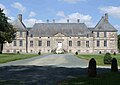
- Saint-Michel Castle, originally from the 12th century, alterations from a later period
- Beaulieu Castle from the 17th century
- Baugisière Castle, rebuilt in 1741
- Mazeau Castle, rebuilt around 1830

Saint-Michel church

Saint-Michel castle

Beaulieu Castle
Baugisière Castle

Mazeau Castle
.jpg)


literature
- Le Patrimoine des Communes de la Vendée. Flohic Editions, Volume 2, Paris 2001, ISBN 2-84234-118-X , pp. 1082-1086.
Web links
Commons : Saint-Michel-le-Cloucq - Collection of images, videos and audio files