
Saint-Cyr-des-Gâts
| Saint-Cyr-des-Gâts | ||
|---|---|---|
|
||
| region | Pays de la Loire | |
| Department | Vendée | |
| Arrondissement | Fontenay-le-Comte | |
| Canton | La Châtaigneraie | |
| Community association | Pays de Fontenay-Vendée | |
| Coordinates | 46 ° 34 ′ N , 0 ° 53 ′ W | |
| height | 49-132 m | |
| surface | 21.08 km 2 | |
| Residents | 534 (January 1, 2017) | |
| Population density | 25 inhabitants / km 2 | |
| Post Code | 85410 | |
| INSEE code | 85205 | |

Saint-Cyr-des-Gâts is a western French community with 534 inhabitants (as of January 1 2017) in Vendée in the region of Pays de la Loire . Nalliers belongs to the arrondissement Fontenay-le-Comte and the canton of La Châtaigneraie (until 2015: canton L'Hermenault ). The inhabitants are called Saint-Cyriens .
location
Saint-Cyr-des-Gâts is located about 35 kilometers east-southeast of La Roche-sur-Yon in the landscape of the Gâtine vendéenne . Saint-Cyr-des-Gâts is surrounded by the neighboring communities of Thouarsais-Bouildroux in the north, Cezais in the northeast, Bourneau in the east and southeast, Marsais-Sainte-Radégonde in the south, Saint-Martin-des-Fontaines in the southwest and Saint-Laurent- de-la-Salle to the west.
Population development
| year | 1962 | 1968 | 1975 | 1982 | 1990 | 1999 | 2006 | 2013 |
| Residents | 682 | 648 | 551 | 502 | 500 | 464 | 515 | 527 |
| Source: Cassini and INSEE | ||||||||
Attractions
- Saint-Cyr church
- Windmill ( Monument historique )
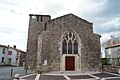
Saint-Cyr church

Windmill
.JPG)

literature
- Le Patrimoine des Communes de la Vendée. Flohic Editions, Volume 1, Paris 2001, ISBN 2-84234-118-X , pp. 377-380.