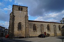
Bourneau
| Bourneau | ||
|---|---|---|
|
|
||
| region | Pays de la Loire | |
| Department | Vendée | |
| Arrondissement | Fontenay-le-Comte | |
| Canton | La Châtaigneraie | |
| Community association | Pays de Fontenay-Vendée | |
| Coordinates | 46 ° 32 ′ N , 0 ° 49 ′ W | |
| height | 38-122 m | |
| surface | 16.34 km 2 | |
| Residents | 734 (January 1, 2017) | |
| Population density | 45 inhabitants / km 2 | |
| Post Code | 85200 | |
| INSEE code | 85033 | |
Bourneau is a French municipality with 734 inhabitants (at January 1, 2017) in the department of Vendée in the region of Pays de la Loire . It belongs to the canton of La Châtaigneraie in the arrondissement of Fontenay-le-Comte .
geography
It is bordered by Saint-Cyr-des-Gâts in the north-west, Cezais in the north, Vouvant in the north- east, Mervent in the south-east, Pissotte and Sérigné in the south and Marsais-Sainte-Radégonde in the south-west . The village center is 95 meters above sea level. The local highway is the department road D938T, which runs between north and south. The Smagne rises in Bourneau . The river called Mère delimits the municipality marker in the southeast and is dammed there by the Barrage de Mervent .
Population development
| year | 1962 | 1968 | 1975 | 1982 | 1990 | 1999 | 2008 | 2014 |
|---|---|---|---|---|---|---|---|---|
| Residents | 694 | 717 | 620 | 736 | 722 | 623 | 777 | 737 |
Attractions
- Saint-Jean-Baptiste Church, Monument historique
- Stolpersteine by Gunter Demnig , see also the list of places with stumbling blocks .
literature
- Le Patrimoine des Communes de la Vendée. Flohic Editions, Volume 1, Paris 2001, ISBN 2-84234-118-X , pp. 357-359.
Web links
Commons : Bourneau - collection of images, videos and audio files

