
Villers-Saint-Frambourg
| Villers-Saint-Frambourg | ||
|---|---|---|
|
||
| local community | Villers-Saint-Frambourg-Ognon | |
| region | Hauts-de-France | |
| Department | Oise | |
| Arrondissement | Senlis | |
| Coordinates | 49 ° 15 ′ N , 2 ° 38 ′ E | |
| Post Code | 60810 | |
| Former INSEE code | 60682 | |
| Incorporation | 1st January 2019 | |
| status | Commune déléguée | |
| Website | http://www.villers-saint-frambourg.fr/ | |
.jpg) Town hall (Mairie) of Villers-Saint-Frambourg |
||

Villers-Saint-Frambourg is a commune Déléguée in the French municipality of Villers-Saint-Frambourg-Ognon with 556 inhabitants (at January 1, 2017) in the department of Oise in the region of Hauts-de-France (before 2016 Picardy ). The inhabitants are called frambourgeois .
The municipality of Villers-Saint-Frambourg merged with Ognon on January 1, 2019 to form the Commune nouvelle Villers-Saint-Frambourg-Ognon. Since then it has had the status of a Commune déléguée. The municipality of Villers-Saint-Frambourg was part of the Senlis arrondissement and the canton of Pont-Sainte-Maxence ( Senlis until 2015 ).
geography
Villers-Saint-Frambourg is located about seven kilometers northeast of Senlis in the Halatte forest. The municipality of Villers-Saint-Frambourg was surrounded by the neighboring municipalities of Pontpoint in the north, Villeneuve-sur-Verberie in the east and northeast, Brasseuse in the east, Ognon in the south, Chamant in the southwest, Fleurines in the west and Pont-Sainte-Maxence in the northwest.
Population development
| 1962 | 1968 | 1975 | 1982 | 1990 | 1999 | 2006 | 2013 |
|---|---|---|---|---|---|---|---|
| 436 | 399 | 470 | 510 | 572 | 582 | 603 | 565 |
| Source: Cassini and INSEE | |||||||
Attractions
See also: List of Monuments historiques in Villers-Saint-Frambourg-Ognon
- Chancy dolmen
- Saint-Médard church from the 12th century, monument historique since 1913
- Darras and Leclère manors

Dolmen
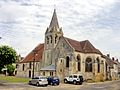
Saint-Médard church
,_dolmen_%27Le_Cheval_Blanc%27_(parcelle_102,_pr%C3%A8s_du_chemin_du_Cheval_Blanc).jpg)
,_%C3%A9glise_Saint-M%C3%A9dard,_vue_d%27ensemble_depuis_le_sud-est.jpg)