
Chamant (Oise)
| Chamant | ||
|---|---|---|
|
||
| region | Hauts-de-France | |
| Department | Oise | |
| Arrondissement | Senlis | |
| Canton | Senlis | |
| Community association | Senlis Sud Oise | |
| Coordinates | 49 ° 13 ' N , 2 ° 37' E | |
| height | 57-117 m | |
| surface | 12 km 2 | |
| Residents | 910 (January 1, 2017) | |
| Population density | 76 inhabitants / km 2 | |
| Post Code | 60300 | |
| INSEE code | 60138 | |
| Website | http://www.chamant.fr/ | |
,_la_mairie.jpg) Town hall (Mairie) of Chamant |
||

Chamant is a French municipality with 910 inhabitants (as of January 1 2017) in the department of Oise in the region of Hauts-de-France . Chamant belongs to the Arrondissement of Senlis and the Canton of Senlis .
geography
Chamant is a small suburb northeast of Senlis . Chamant is surrounded by the neighboring communities Villers-Saint-Frambourg-Ognon in the north and north-east, Barbery in the east, Mont-l'Évêque in the south and south-east and Senlis in the south and west.
Autoroute A1 runs through the municipality .
Population development
| 1962 | 1968 | 1975 | 1982 | 1990 | 1999 | 2006 | 2013 |
|---|---|---|---|---|---|---|---|
| 590 | 619 | 720 | 665 | 953 | 957 | 929 | 912 |
| Source: Cassini and INSEE | |||||||
Attractions
See also: List of Monuments historiques in Chamant (Oise)
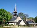
- Notre-Dame church, monument historique since 1921
- Sainte-Foy church in Balagny-sur-l'Aunette, a historic monument since 1970
- Notre-Dame-de-Bon-Secours chapel
- Water tower, constructed in 1895 by Gustave Eiffel, Monument historique since 1998

Notre-Dame church

Sainte-Foy church
Notre-Dame-de-Bon-Secours chapel

Water tower
,_l%27%C3%A9glise_Notre-Dame.jpg)
,_hameau_de_Balagny-sur-Aunette,_l%27%C3%A9glise_depuis_le_sud.jpg)

,_Ch%C3%A2teau_d%27eau.jpg)
Web links
Commons : Chamant - collection of images, videos and audio files