
Borest
| Borest | ||
|---|---|---|
|
||
| region | Hauts-de-France | |
| Department | Oise | |
| Arrondissement | Senlis | |
| Canton | Nanteuil-le-Haudouin | |
| Community association | Senlis Sud Oise | |
| Coordinates | 49 ° 11 ′ N , 2 ° 40 ′ E | |
| height | 59-123 m | |
| surface | 12.78 km 2 | |
| Residents | 334 (January 1, 2017) | |
| Population density | 26 inhabitants / km 2 | |
| Post Code | 60300 | |
| INSEE code | 60087 | |
| Website | http://www.borest.org/ | |
,_mairie.jpg) Town Hall (Mairie) of Borest |
||

Borest is a French municipality with 334 inhabitants (as of January 1 2017) in the department of Oise in the region of Hauts-de-France . It belongs to the Arrondissement of Senlis and the canton of Nanteuil-le-Haudouin .
geography
Borest is located about 45 kilometers northeast of Paris on the Nonette . Borest is surrounded by the neighboring communities of Barbery in the north, Montépilloy in the northeast, Baron in the east, Fontaine-Chaalis in the south and east and Mont-l'Évêque in the west.
Population development
| year | 1962 | 1968 | 1975 | 1982 | 1990 | 1999 | 2006 | 2013 |
| Residents | 312 | 295 | 310 | 271 | 343 | 326 | 339 | 329 |
| Source: Cassini and INSEE | ||||||||
Attractions
See also: List of Monuments historiques in Borest
- Menhir La Queue de Gargantua
- Saint-Martin church from the 12th century, monument historique since 1930
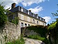
- Sainte-Geneviève priory from the 12th century with conversions and additions from the 14th century, monument historique since 1930
- La Bossière Castle
- Saint-Vincent mansion
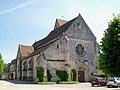
Saint Martin Church

Remains of the former priory
La Boissière Castle

Saint-Vincent mansion
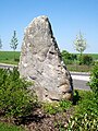
Menhir Queue de Gargantua
,_l%27%C3%A9glise_Saint-Martin.jpg)
,_ancien_logis_du_prieur%C3%A9_Sainte-Genevi%C3%A8ve.jpg)
,_ch%C3%A2teau_de_la_Boissi%C3%A8re.jpg)
,_manoir_Saint-Vincent.jpg)
,_menhir_dit_la_Queue_de_Gargantua.jpg)
Web links
Commons : Borest - collection of images, videos and audio files