
Pontarmé
| Pontarmé | ||
|---|---|---|
|
||
| region | Hauts-de-France | |
| Department | Oise | |
| Arrondissement | Senlis | |
| Canton | Senlis | |
| Community association | Senlis Sud Oise | |
| Coordinates | 49 ° 9 ' N , 2 ° 33' E | |
| height | 50-87 m | |
| surface | 13.24 km 2 | |
| Residents | 817 (January 1, 2017) | |
| Population density | 62 inhabitants / km 2 | |
| Post Code | 60520 | |
| INSEE code | 60505 | |
| Website | http://www.pontarme.fr/ | |
 Town hall (Mairie) of Pontarmé |
||

Pontarmé is a French municipality with 817 inhabitants (as of January 1 2017) in the department of Oise in the region of Hauts-de-France . Pontarmé belongs to the Arrondissement of Senlis and the Canton of Senlis . The inhabitants are called Pontarméens .
geography
Pontarmé is a small suburb southwest of Senlis in the Chantilly Forest. Pontarmé is surrounded by the neighboring communities of Avilly-Saint-Léonard in the north, Senlis in the north and northeast, Mont-l'Évêque in the east and northeast, Thiers-sur-Thève in the east and southeast, La Chapelle-en-Serval in the south, Orry -la-Ville in the southwest and Chantilly in the west and northwest.
Population development
| 1962 | 1968 | 1975 | 1982 | 1990 | 1999 | 2006 | 2013 |
|---|---|---|---|---|---|---|---|
| 412 | 398 | 405 | 473 | 644 | 585 | 664 | 846 |
| Source: Cassini and INSEE | |||||||
Attractions
See also: List of Monuments historiques in Pontarmé
- Saint-Pierre church
- Pontarmé Castle, originally from the 12th century, has been a monument historique since 1986

Saint-Pierre church
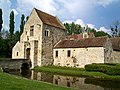
Pontarmé Castle

,_ch%C3%A2teau,_vue_depuis_le_sud-ouest.jpg)
Web links
Commons : Pontarmé - collection of images, videos and audio files