
Fresnoy-en-Thelle
| Fresnoy-en-Thelle | ||
|---|---|---|
|
||
| region | Hauts-de-France | |
| Department | Oise | |
| Arrondissement | Senlis | |
| Canton | Méru | |
| Community association | Thelloise | |
| Coordinates | 49 ° 12 ′ N , 2 ° 16 ′ E | |
| height | 62–112 m | |
| surface | 6.28 km 2 | |
| Residents | 915 (January 1, 2017) | |
| Population density | 146 inhabitants / km 2 | |
| Post Code | 60530 | |
| INSEE code | 60259 | |
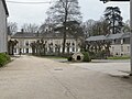
 Town hall (Mairie) of Fresnoy-en-Thelle |
||

Fresnoy-en-Thelle is a French municipality with 915 inhabitants (as of January 1 2017) in Oise in the region of Hauts-de-France . The municipality is located in the arrondissement of Senlis and is part of the Communauté de communes Thelloise and the canton of Méru (until 2015: canton of Neuilly-en-Thelle ).
geography
Fresnoy-en-Thelle is located in the Pays de Thelle , about 23 kilometers west of Senlis . Fresnoy-en-Thelle is surrounded by the neighboring communities Neuilly-en-Thelle in the north, Morangles in the east, Le Mesnil-en-Thelle in the south and south-east, Chambly in the south and south-west, Belle-Église and Bornel in the west and south-west and Puiseux -Hauberger in the northwest.
Population development
| 1962 | 1968 | 1975 | 1982 | 1990 | 1999 | 2006 | 2013 | |
|---|---|---|---|---|---|---|---|---|
| 274 | 260 | 400 | 724 | 828 | 818 | 921 | 943 | |
| Source: Cassini and INSEE | ||||||||
Attractions
- Saint-Nicolas church from the 12th century (see also: List of Monuments historiques in Fresnoy-en-Thelle )
- Lamberval Castle

Saint-Nicolas church
Lamberval Castle


Web links
Commons : Fresnoy-en-Thelle - collection of images, videos and audio files