Précy-sur-Oise
| Précy-sur-Oise | ||
|---|---|---|

|
|
|
| region | Hauts-de-France | |
| Department | Oise | |
| Arrondissement | Senlis | |
| Canton | Montataire | |
| Community association | Thelloise | |
| Coordinates | 49 ° 12 ′ N , 2 ° 22 ′ E | |
| height | 23-123 m | |
| surface | 9.65 km 2 | |
| Residents | 3,205 (January 1, 2017) | |
| Population density | 332 inhabitants / km 2 | |
| Post Code | 60460 | |
| INSEE code | 60513 | |
| Website | http://www.precy.net/ | |
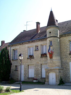
 Town hall of Précy-sur-Oise |
||
Précy-sur-Oise is a French municipality with 3205 inhabitants (as of January 1 2017) in the department of Oise in the region of Hauts-de-France . Précy-sur-Oise is part of the Senlis arrondissement and the Montataire canton . Its inhabitants call themselves Précéens .
geography
Précy-sur-Oise is located on the River Oise . The municipality is part of the Oise-Pays de France Regional Nature Park . Précy-sur-Oise is surrounded by the neighboring communities Blaincourt-lès-Précy in the north and north-west, Villers-sous-Saint-Leu in the east and north-east, Gouvieux in the south-east, Gouvieux in the south-east, Boran-sur-Oise in the south and south-west as well Crouy-en-Theile in the north-west.
history
Précy is mentioned as early as 750 as the manor of the house of Montmorency-Luxembourg.
Population development
| year | 1962 | 1968 | 1975 | 1982 | 1990 | 1999 | 2006 | 2011 |
| Residents | 1,860 | 2,045 | 2.113 | 2,694 | 3.137 | 3,120 | 3,335 | 3.210 |
Attractions
- Saint-Pierre-Saint-Paul church, Gothic construction, started at the end of the 12th century, finished around 1570, Monument historique since 1950 (see also: List of Monuments historiques in Précy-sur-Oise )
- Castle of Précy-sur-Oise
- Érables castle with park
- Verdun square with fountain
Community partnerships
There is a partnership with the German municipality of Hütschenhausen in Rhineland-Palatinate.

