
Vauciennes (Oise)
| Vauciennes | ||
|---|---|---|
|
||
| region | Hauts-de-France | |
| Department | Oise | |
| Arrondissement | Senlis | |
| Canton | Crépy-en-Valois | |
| Community association | Pays de Valois | |
| Coordinates | 49 ° 14 ' N , 3 ° 2' E | |
| height | 71-167 m | |
| surface | 6.36 km 2 | |
| Residents | 682 (January 1, 2017) | |
| Population density | 107 inhabitants / km 2 | |
| Post Code | 60117 | |
| INSEE code | 60658 | |
,_mairie.JPG) Town Hall (Mairie) of Vauciennes |
||

Vauciennes is a French municipality with 682 inhabitants (as of January 1 2017) in the department of Oise in the region of Hauts-de-France . It belongs to the Arrondissement of Senlis and the canton of Crépy-en-Valois .
geography
Vauciennes is located about 40 kilometers east-northeast of Senlis and about 33 kilometers south-southeast of Compiègne . Vauciennes is surrounded by the neighboring communities of Vez in the north, Largny-sur-Automne in the northeast, Coyolles in the south, west and east, Ivors in the south and Vaumoise in the west and north-west.
The Route nationale 2 runs through the north of the municipality .
Residents
| 1962 | 1968 | 1975 | 1982 | 1990 | 1999 | 2006 | 2013 |
|---|---|---|---|---|---|---|---|
| 737 | 717 | 710 | 813 | 763 | 661 | 581 | 684 |
| Source: Cassini and INSEE | |||||||
Attractions
See also: List of Monuments historiques in Vauciennes (Oise)
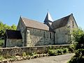
- Saint-Léger church in Vauciennes from the 12th century, monument historique since 1951
- Church of Sainte-Geneviève in Chavres, monument historique since 1951
- Manor house of Le Plessis-aux-Bois, Monument historique since 1999

Saint-Léger church
Sainte-Geneviève church
,_%C3%A9glise_Saint-L%C3%A9ger,_vue_depuis_le_sud_2.JPG)
,_chapelle_Sainte-Genevi%C3%A8ve_de_Chavres,_vue_depuis_le_sud-ouest.jpg)
Web links
Commons : Vauciennes - collection of images, videos and audio files