
Coye-la-Foret
| Coye-la-Foret | ||
|---|---|---|

|
|
|
| region | Hauts-de-France | |
| Department | Oise | |
| Arrondissement | Senlis | |
| Canton | Chantilly | |
| Community association | Aire Cantilienne | |
| Coordinates | 49 ° 9 ′ N , 2 ° 28 ′ E | |
| height | 31-126 m | |
| surface | 6.96 km 2 | |
| Residents | 3,931 (January 1, 2017) | |
| Population density | 565 inhabitants / km 2 | |
| Post Code | 60580 | |
| INSEE code | 60172 | |
| Website | www.coyelaforet.com | |

Coye-la-Forêt is a French municipality with 3931 inhabitants (at January 1, 2017) in the department of Oise in the region of Hauts-de-France . It is located 35 kilometers north of Paris .
Coye-la-Forêt is served by the RER D of the Paris suburbs and the TER Picardie .
The forest of Chantilly extends north of the commune , where the artificial lakes Étangs de Commelles are located.
| Population development | ||||||||||||||
|---|---|---|---|---|---|---|---|---|---|---|---|---|---|---|
| year | 1793 | 1856 | 1901 | 1946 | 1954 | 1962 | 1968 | 1975 | 1982 | 1990 | 1999 | 2007 | ||
| Residents | 675 | 948 | 1,340 | 1,663 | 1,813 | 2,075 | 2,509 | 3,048 | 3,094 | 3,199 | 3,509 | 3,757 | ||
See also

Center of Coye-la-Forêt
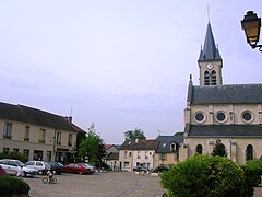
Main square of Coye-la-Forêt


Web links
Commons : Coye-la-Forêt - collection of images, videos and audio files