
Rully (Oise)
| Rully | ||
|---|---|---|
|
||
| region | Hauts-de-France | |
| Department | Oise | |
| Arrondissement | Senlis | |
| Canton | Pont-Sainte-Maxence | |
| Community association | Senlis Sud Oise | |
| Coordinates | 49 ° 14 ' N , 2 ° 44' E | |
| height | 72-147 m | |
| surface | 15.45 km 2 | |
| Residents | 720 (January 1, 2017) | |
| Population density | 47 inhabitants / km 2 | |
| Post Code | 60810 | |
| INSEE code | 60560 | |
| Website | http://www.rullybray.fr/ | |
,_mairie_1.jpg) Town Hall (Mairie) by Rully |
||

Rully is a French municipality with 720 inhabitants (as of January 1 2017) in the department of Oise in the region of Hauts-de-France (before 2016: Picardie ). It belongs to the arrondissement of Senlis and the canton of Pont-Sainte-Maxence . Rully is part of the Communauté de communes Senlis Sud Oise .
geography
Rully is located about 21 kilometers south-southwest of Compiègne and about 50 kilometers north-northeast of Paris . The Aunette rises here . Rully is surrounded by the neighboring communities of Raray in the north, Néry in the northeast, Trumilly in the east, Fresnoy-le-Luat in the southeast, Montépilloy in the south, Barbery in the southwest and Brasseuse in the west.
Population development
| year | 1962 | 1968 | 1975 | 1982 | 1990 | 1999 | 2006 | 2013 |
| Residents | 606 | 561 | 587 | 561 | 627 | 732 | 725 | 730 |
| Source: Cassini and INSEE | ||||||||
Attractions
See also: List of Monuments historiques in Rully (Oise)
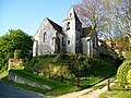
- Notre-Dame-Saint-Rieul church from the 12th century, monument historique since 1862
- Saint-Georges de Bray church from the 12th century, monument historique since 1951
- Saint-Victor priory in Bray, monument historique since 1943
- Renaissance mansion

Notre-Dame-Saint-Rieul church
Saint-Georges Church of Bray

Saint-Victor priory

Mansion
,_%C3%A9glise_class%C3%A9e_M.H..jpg)
,_%C3%A9glise_de_Bray.jpg)
,_prieur%C3%A9_XIIIe_si%C3%A8cle,_class%C3%A9_M.H..jpg)
,_manoir_Renaissance_de_la_ferme_en_face_de_la_mairie.jpg)