
Ivors
| Ivors | ||
|---|---|---|
|
||
| region | Hauts-de-France | |
| Department | Oise | |
| Arrondissement | Senlis | |
| Canton | Nanteuil-le-Haudouin | |
| Community association | Pays de Valois | |
| Coordinates | 49 ° 12 ' N , 3 ° 1' E | |
| height | 82-151 m | |
| surface | 8.35 km 2 | |
| Residents | 259 (January 1, 2017) | |
| Population density | 31 inhabitants / km 2 | |
| Post Code | 60141 | |
| INSEE code | 60320 | |

Ivor is a French municipality with 259 inhabitants (as of January 1 2017) in the department of Oise in the region of Hauts-de-France (before 2016: Picardy ); it belongs to the arrondissement of Senlis and the canton of Nanteuil-le-Haudouin .
geography
Ivors is about 50 kilometers east-southeast of Senlis . Ivors is surrounded by the neighboring communities of Coyolles in the north, south and west, Vauciennes in the north, Boursonne in the east, Autheuil-en-Valois in the south-east and Cuvergnon in the south.
Population development
| year | 1962 | 1968 | 1975 | 1982 | 1990 | 1999 | 2006 | 2013 |
| Residents | 221 | 215 | 208 | 163 | 198 | 211 | 228 | 244 |
| Source: Cassini and INSEE | ||||||||
Attractions
See also: List of Monuments historiques in Ivors
- Saint-Etienne church from the 12th century
- Portal to the castle, Monument historique
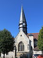
Saint-Etienne church

Portal to the old castle


Web links
Commons : Ivors - collection of images, videos and audio files