
Ercuis
| Ercuis | ||
|---|---|---|

|
|
|
| region | Hauts-de-France | |
| Department | Oise | |
| Arrondissement | Senlis | |
| Canton | Méru | |
| Community association | Thelloise | |
| Coordinates | 49 ° 14 ′ N , 2 ° 18 ′ E | |
| height | 84-157 m | |
| surface | 4.38 km 2 | |
| Residents | 1,609 (January 1, 2017) | |
| Population density | 367 inhabitants / km 2 | |
| Post Code | 60530 | |
| INSEE code | 60212 | |
 Church and town hall (Mairie) of Ercuis |
||

Ercuis is a French commune with 1,609 inhabitants (as of January 1 2017) in Oise in the region of Hauts-de-France . The municipality is located in the arrondissement of Senlis and is part of the Communauté de communes Thelloise and the canton of Méru (until 2015: canton of Neuilly-en-Thelle ).
geography
Ercuis is located in the Pays de Thelle , about 20 kilometers west-northwest of Senlis . Ercuis is surrounded by the neighboring communities Neuilly-en-Thelle in the north and west, Cires-lès-Mello in the north and north-east, Blaincourt-lès-Précy in the east and south-east and Crouy-en-Thelle in the south.
Population development
| 1962 | 1968 | 1975 | 1982 | 1990 | 1999 | 2006 | 2013 | |
|---|---|---|---|---|---|---|---|---|
| 640 | 664 | 743 | 985 | 1,262 | 1,566 | 1,461 | 1,466 | |
| Source: Cassini and INSEE | ||||||||
Attractions
- Saint-Nicolas church
- Ercuis Castle
- Le Thelle estate

Saint-Nicolas church
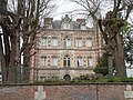
lock
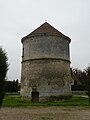
Tower of the Le Thelle estate


Personalities
- Guillaume d'Ercuis (around 1255–1314 / 1315), royal notary and almsman
Web links
Commons : Ercuis - collection of images, videos and audio files
- Monuments historiques (objects) in Ercuis in the base Palissy of the French Ministry of Culture