
Rhuis
| Rhuis | ||
|---|---|---|
|
||
| region | Hauts-de-France | |
| Department | Oise | |
| Arrondissement | Senlis | |
| Canton | Pont-Sainte-Maxence | |
| Community association | Pays d'Oise et d'Halatte | |
| Coordinates | 49 ° 18 ' N , 2 ° 42' E | |
| height | 30-120 m | |
| surface | 2.7 km 2 | |
| Residents | 140 (January 1, 2017) | |
| Population density | 52 inhabitants / km 2 | |
| Post Code | 60410 | |
| INSEE code | 60536 | |
| Website | http://www.rhuis60.fr/ | |
,_mairie,_Grande_rue.jpg) Town hall (Mairie) of Rhuis |
||

Rhuis is a French municipality with 140 inhabitants (as of January 1 2017) in the department of Oise in the region of Hauts-de-France (before 2016: Picardie ). It belongs to the arrondissement of Senlis and the canton of Pont-Sainte-Maxence . Rhuis is part of the Communauté de communes des Pays d'Oise et d'Halatte .
geography
Rhuis is about 18 kilometers southwest of Compiègne and about 21 kilometers north-northeast of Senlis . Rhuis is surrounded by the neighboring communities Longueil-Sainte-Marie in the north, Verberie in the east, Villeneuve-sur-Verberie in the south and south-west, Roberval in the west and south-west and Pontpoint in the west and north-west.
Population development
| year | 1962 | 1968 | 1975 | 1982 | 1990 | 1999 | 2006 | 2013 |
| Residents | 82 | 71 | 62 | 62 | 63 | 84 | 125 | 141 |
| Source: Cassini and INSEE | ||||||||
Attractions
See also: List of Monuments historiques in Rhuis
- Saint-Gervais-Saint-Protais church from the 12th century, monument historique since 1894
- Menhir Demoiselle de Rhuis , Monument historique since 1982
- Le Joncquoy Mill
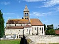
Saint-Gervais-Saint-Protais church

Menhir Demoiselle de Rhuis

Le Joncquoy Mill
,_vue_de_l%27%C3%A9glise_depuis_le_sud.jpg)

,_moulin_du_Joncquoy.jpg)