
Waltersdorf (Heideblick)
|
Waltersdorf
Municipality Heideblick
Coordinates: 51 ° 49 ′ 11 " N , 13 ° 38 ′ 51" E
|
||
|---|---|---|
| Height : | 71 m above sea level NHN | |
| Area : | 10.92 km² | |
| Residents : | 372 (December 31, 2016) | |
| Population density : | 34 inhabitants / km² | |
| Incorporation : | December 31, 2001 | |
| Postal code : | 15926 | |
| Area code : | 035455 | |
Location of Waltersdorf in Brandenburg |
||

Waltersdorf ( Lower Sorbian Wałtaŕejce ) is a district of the municipality Heideblick in the district of Dahme-Spreewald in Brandenburg .
history
Waltersdorf was first mentioned in a document in 1392, but the stone church from the 13th century indicates that the place is much older. The granite ashlar building is one of the oldest around Luckau . From 1739 Waltersdorf was owned by the von Pfuel family . Gustav Lebrecht von Pfuel († 1787) was the master of Waltersdorf and the desert brand . His tomb is in the Wüstermarke village church . In 1807 Waltersdorf is owned by a major von Pfuel.
Geography and transport links
The place is on the K 6133, the B 87 runs not far to the north and the B 96 to the east .
Southeast of Riede Beck is the conservation area Lausitzer border barrier between Miter, Crinitz and bush meadows .
Attractions
Architectural monuments
In the list of monuments in Heideblick there are five monuments for Waltersdorf .
- the village church of Waltersdorf
- the manor complex with mansion (Waltersdorf 37)
- the marble sculpture by Walter Schott, in the manor park
- the rectory (Waltersdorf 56)
- the Möbiusmühle with Mühlenfließ, weir and mill pond (Waltersdorfer Bahnhof 1)

Waltersdorf village church
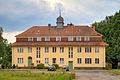
Waltersdorf manor


See also
Web links
- Waltersdorf on the website of the community Heideblick
Individual evidence
- ↑ Community and district directory of the state of Brandenburg. Land surveying and geographic base information Brandenburg (LGB), accessed on June 20, 2020.
- ↑ Waltersdorf .
- ^ Leopold von Ledebur: Adelslexikon der Prussischen Monarchy . Rauh, 1856, pp. 196-197.
- ↑ [anonymous AC02905590]: Dresdner ads . Adreßcomptoir, 1807, p. 597.

Districts:
Beesdau (Bezdow) |
Bornsdorf (Bórńšojce) |
Falkenberg (Sokolnica) |
Miter (Jarin) |
Goßmar (Góšmar) |
Langengrassau |
Pitch pimples |
Riedebeck |
Schwarzenburg |
Walddrehna (Serbski Drjenow) |
Waltersdorf (Wałtaŕejce) |
Wehnsdorf |
Weißack (Wusoka) |
Desert brand
Parts of the municipality: Grünswalde | Neumühle | Neusorgefeld | Paper mill | Bad luck | Concern | Trebbinchen (Trjebink)