
Redinghoven moated castle


The property of the former Wasserburg Redinghoven in Friesheim was first mentioned in a document in 1399. Today Redinghoven is the best preserved castle complex in the village.
history
Friesheim lies in the fertile valley of the Rotbach . The agriculture, which has always been intensively practiced there, produced good yields and thus an excellent return for the secular and spiritual landlords . This led early in its history to a concentration of Friesenheimer manorial system , which has become a Hofverband developed. Count Emundus von Friesheim, Count of the Kölngau , bequeathed his extensive Friesheim property to the Cologne Cathedral Monastery . The provost of the cathedral granted castles and estates from this property as fiefdoms . One of these possessions is the Redinghoven moated castle.
Place and fortifications
The Rotbach , which rises in the Eifel and flows through Friesheim on its way to the Erft , with its abundant amounts of water, also offered numerous fortified places or castles a protective function in many places in the past . The protective trenches fed by its water surrounded large and small towns and filled the moats of the moated castles with drawbridges . The less well-off residents of the village of Friesheim, in the area of which there were several well-fortified castles and courtyards, were fortified by moats and thick hedges.

Rotbach

Rotbach Bridge
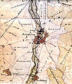
Tranchotkarte, Redinghoven, Friesheim and Niederberg


Sketches and maps
The Walloon painter Renier Roidkin made sketches of the then Electoral Cologne possessions of Friesheim on his hikes around 1730 . His drawings are a complement to the sparsely survived pictorial representations of that time.
In addition to the map of the French geodesist Tranchot , which shows and designates the streams of the region that are useful for defense (the Rothebach ), a cadastral map from 1810 clearly illustrates the fortifications and ditch systems that were still preserved during the French era .

This original cadastral map shows the existing castles (A), the fortified courtyards (B), the church (C) and the mill of the village (D). Nine fortified structures can be seen on the map, which were called aristocratic residences or castles. Two are outside the village (Burg Redinghoven and the Effertsburg), two (Wymarsburg and White Castle) are within the fortification (moat) of the village of Friesheim, which was still visible in the area at that time. Two fortified courtyards and several moats were drawn in, in which houses and courtyard buildings have stood over the centuries. Conclusions about medieval conditions can only be reconstructed to a limited extent from the map.
Gentlemen on Redinghoven
The predecessor of Burg Redinghoven was the castle of Wieland Braun, which was called Braunsgut . She was surrounded by a moat, outside the village of Friesenheim in Niederwig (.. the walks, the ghat uf the bach ) and was a fief of the Cologne cathedral dean . It was first mentioned in 1399 on the occasion of a description of the property by Engelbert von Friesheim, whose farmstead came across Brauns Weiher.


After Wieland Braun's death, the castle was sold to Johann Beissel von Gymnich in 1466 , who sold it to the Friesheim mayor Heinrich von Meller. His daughter Iburg von Meller, who was married to Peter Wolff von Metternich , inherited the castle, which then remained in the family's possession for several generations .
At the end of the 16th century the ownership changed again. By marrying in 1599 the castle and its associated lands came to Hans Philipp von Hoheneck, who married Anna Wolff von Metternich, as a noble knight's seat ( noble Seeß ).
In 1602 the property is expanded through a considerable acquisition. In a purchase agreement between Thomas von Wesel (previously the tenant of the estate) and Hans Philipp von Hoheneck, Provost Ferdinand von Bayern confirms that Thomas von Wesel has declared that he owned the Lehngut zu Friesheim, the Steprather Hof, which was currently (1591) was burned down by the "static Reutterei" in the ground, sold to Philipp von Hoheneck and his wife Anna Wolff von Metternich.
After several changes, the property went to the Wilhelm von der Juden family from Cologne in 1670. Like his ancestor Franz Konstantin von der Juden, Wilhelm was several times mayor of the Free Imperial City of Cologne . His son, Franz Konstantin (* 1668 + 9 June 1735), bequeathed the property to his wife Margarethe, née von Wymar, who married the Baron von Redinghoven in 1736, after whom the castle is named today.
In her will from 1761, Anna Margarethe widow von Redinghoven, née von Wymar, decreed that her brother Franz Kaspar von Wymar, mayor of Cologne, would be the sole heir of her property. In 1764 the fiefdom passed to Franz Kaspar von Wymar for a short time, who died in 1772. Apparently the property stayed in the family. In 1786 Johann Alexander Konstantin von Wymar was enfeoffed again with the Braunsgut and the Steprathsgut zu Friesheim as it had been enfeoffed on May 11, 1779. During the French era, Burg Redinghoven became the property of Franz Josef Litz in 1801. The successors in the property were the Stryck, Wolfgarten and Leser families.
Description of the current system
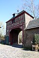
The road from Lechenich leads via Ahrem to the northern edge of Friesheim and then becomes the Niederweg leading into the town center. A partially paved driveway branching off at a figure of St. John of Nepomuk leads somewhat sloping as a birch avenue to the gatehouse of the moated castle Redinghoven.

Birch avenue to the gatehouse

North side

Mansion west side

Southeast side

Aerial photograph (2015)


In front of this gate there used to be a drawbridge that spanned the surrounding moat , the remains of which were found during excavation work. Today's moat, which is still connected to the Rotbach, encompasses the property on the east, south and west sides, the northern part ends after a few meters. The adjacent meadows include the courtyard areas of the former Steprather Hof and the Winrich-Kochs estate. Their trench systems, which were connected to one another, were backfilled in the 1970s to make better use of the site. In the middle above the arch there is a coat of arms of the ancestors of the current owner (from Wymarsche line). It is part of the Redinghoven / von Wymar alliance coat of arms from 1741. The most important features of the two coats of arms can be seen:
- Redinghoven's coat of arms: a rising tip, a lily pad in the upper right and left corner, and a peacock turned to the right on the side.
- The coat of arms of Wymar: an inclined cross, a dog on the side.
The mansion itself is completely enclosed by the water. It can be entered from the large inner courtyard, which is surrounded by farm buildings, via an ascending arched bridge . Assumptions that an earlier predecessor building arose from a moth have not yet been verified by studies . The farm buildings are more recent, the south wing of the building has been converted for residential purposes, the rest are used for agricultural purposes.

West side of the farm buildings

Inner courtyard of the outer bailey
Inner courtyard gatehouse

Cologne ceiling


The foundations of the manor house reach about 1½ meters deep into the earth. Above the water level, the basement rises like a plinth . It has vaulted rooms with left bulges of the loopholes . Applied plaster does not allow a view of the old masonry.
The manor house of the castle complex, made of red-brown brick , was laid out in a north-south direction. It consists of several components, the façades of which end on the northern front after the second floor with offset, recessed stepped gables . The elongated older and the somewhat shorter younger building section, the entrances of which are on the north-west side, are equipped with a total of 28 lattice windows reconstructed according to the old pattern . Window frames and some corner stones in the masonry of the north wall are made of sandstone . The slate roof has three dormers in the east and two in the south and two in the west .
The rooms on the upper floors are connected by wooden stairs. Ceilings and floors consist of strong beams and planks, some of which are still known as Cologne ceilings .
The current owners, whose gatehouse adorns the alliance coat of arms of their ancestors "von Redinghoven and von Wymar" from 1741, are preserving the property in a succession that has now lasted for many centuries .
literature
- Frank Kretzschmar: Erftkreis cultural region - losses of a monument landscape , Erftkreis publication No. 144, Cologne 1991, ISBN 3-7927-1228-8
- K. and H. Stommel: Sources on the history of the city of Erftstadt , Volumes I to V, 1990 to 1998.
- Olaf Kalscheuer: Elements of a local church history from Friesheim to the end of the 19th century , 1998
Web links
Individual evidence
- ↑ Frank Kretzschmar, p. 47
- ^ Original cadastral map, printed in: Kurköln, Land unter dem Krummstab, essays and documents. Kevelaer 1985. ISBN 3-7666-9431-6 , page 43
- ↑ HAStK Domstift files 3c page 6 ff.
- ↑ HAStK Domstift A 3c p. 193, p. 195, p. 225
- ↑ Stommel sources No. 2159
- ^ Elector Ferdinand had been provost of the cathedral in Cologne since 1598. Literature: HGMolitor: The Archdiocese of Cologne . 3rd volume. Cologne 2008. page 239
- ↑ The buildings of the Steprather Hof in Niederwig were destroyed in 1591. Hermann von Weinsberg Volume IV, pages 132-133, reports on 17 burned houses and 3 burned farms in Friesheim.
- ↑ HAStK Domstift certificate No. 2 / D17
- ↑ Oidtmann Vol. 9 Folder 699 Judden, edited and edited by H. Schleicher
- ↑ HASTK wills 1 / W 453, published in 1318 Oidtmann wallet Wymar
- ↑ HAStK Domstift U No. 1 / D9, U No. 2 / D10, U No. 2 / D20, U No. 3 / D21, U No. 2 / D22, U No. 1 / D23. Ibid. HUANA No. 1/1442. Ibid. Domstift files 3E p. 85 and p. 105; Aakten cathedral pen 3F p. 272
- ^ K. Stommel: The French population lists from Erftstadt . Erftstadt 1989
- ↑ The coats of arms are slightly changed on the depiction on the gatehouse. A detailed description of the coat of arms can be found in Oidtmann Folder 969 and Folder 1318.
Coordinates: 50 ° 45 ′ 37.1 ″ N , 6 ° 46 ′ 33.2 ″ E
