Wernsdorf (Starkenberg)
|
Wernsdorf
Municipality Starkenberg
Coordinates: 50 ° 58 ′ 30 ″ N , 12 ° 14 ′ 58 ″ E
|
||
|---|---|---|
| Height : | 250 m above sea level NN | |
| Residents : | 53 (2012) | |
| Incorporation : | July 1, 1950 | |
| Incorporated into: | Naundorf | |
| Postal code : | 04617 | |
| Area code : | 034495 | |
|
Location of Wernsdorf in Thuringia |
||
|
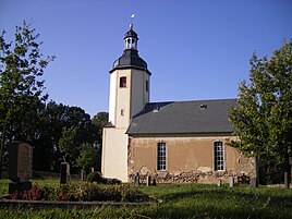
Village church
|
||
Wernsdorf is a district of the Starkenberg community in the Altenburger Land district in Thuringia .
location
The district of Wernsdorf is located on the edge of the Leipzig lowland bay in the Altenburger-Zeitzer loess hill country on soils similar to black earth. The village is four kilometers west of Starkenberg and 17 kilometers from the district town of Altenburg . The geographic height of the place is 250 m above sea level. NN . The Gerstenbach flows through the village . To the west of Wernsdorf is the state border with Saxony-Anhalt .
history
The village was first mentioned on March 12, 1279. In 1715 the residents built the new church.
Wernsdorf is one of the few places in the Altenburger Land that historically did not belong to Saxony-Altenburg . As with the neighboring towns of Tanna and Naundorf, the manor was initially at the Kayna manor , which is why it was also known as the Kayna village . Later, the manor was at the manor Kleinbraunshain , whose five associated towns formed an exclave until 1815 , which belonged to the Borna district of Saxony .
As a result of the resolutions of the Congress of Vienna , the exclave of the five Kaynaic villages came to Prussia in 1815 . It went on in 1816 in the newly formed district of Zeitz in the administrative district of Merseburg in the province of Saxony .
On October 1, 1938, Tanna was incorporated into Wernsdorf. The municipality of Wernsdorf with the district Tanna again came to the municipality of Naundorf on July 1, 1950 . At that time, the three places belonged to the state of Saxony-Anhalt (1945–1952) in the Zeitz district, after the Prussian province of Saxony (1815–1944) was dissolved on July 1, 1944 and the administrative district of Merseburg to the province of Halle-Merseburg (1944–1945) has been. With the administrative reform in the GDR on July 25, 1952, the community Naundorf with Wernsdorf and Tanna came to the district of Schmölln in the district of Leipzig . On January 1, 1957, it was reclassified to the Altenburg district in the Leipzig district, which had belonged to Thuringia as the Altenburg district since 1990 and was added to the Altenburger Land district in 1994. With the incorporation of the Naundorf community into the Starkenberg community, Wernsdorf became a district of the Starkenberg community on December 1, 2008. In 2012, 53 people lived in the village.
Individual evidence
- ↑ Official topographic maps of Thuringia 1: 10,000. LK Altenburg, LK Greiz, district-free city of Gera . In: Thuringian Land Survey Office (Hrsg.): CD-ROM series Top10 . CD 5. Erfurt 1999.
- ^ Wolfgang Kahl : First mention of Thuringian towns and villages. A manual. Verlag Rockstuhl, Bad Langensalza, 2010, ISBN 978-3-86777-202-0 , p. 311
- ↑ Wernsdorf as property belonging to the Kleinbraunshain manor in the Borna district in the book "Geography for all Stands", p. 552
- ↑ Main Convention Congress of Vienna, Art. 1, Abs.29, p.8
- ^ The Zeitz district in the municipal directory 1900
- ↑ Tanna on gov.genealogy.net
- ^ Wernsdorf on gov.genealogy.net
- ↑ Michael Rademacher: German administrative history from the unification of the empire in 1871 to the reunification in 1990. zeitz.html. (Online material for the dissertation, Osnabrück 2006).
- ↑ Wernsdorf on the website of the Starkenberg community.Retrieved on May 12, 2012


