Wisshorn
| Wisshorn | ||
|---|---|---|
|
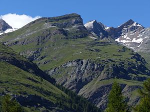
Wisshorn (middle) with Platthorn and Mettelhorn |
||
| height | 2936 m above sea level M. | |
| location | District of Visp , Canton of Valais , Switzerland | |
| Mountains | Valais Alps , Weisshorn Group | |
| Dominance | 0.3 km → Platthorn | |
| Notch height | 25 m ↓ unnamed notch | |
| Coordinates | 622 908 / 98481 | |
|
|
||
The Wisshorn is 2936 m above sea level. M. high mountain in the canton of Valais . The summit of the Wisshorn is just under 2 km northwest of Zermatt .
The Wisshorn, which is largely overgrown with grass up to the summit, offers a comprehensive view of around twenty four-thousand-meter peaks in the Valais Alps , including Dom , Täschhorn , Allalinhorn , Alphubel , Rimpfischhorn , Strahlhorn , Monte Rosa , Breithorn , Matterhorn , Ober Gabelhorn , Zinalrothorn and Weisshorn .
Ascent
The summit can be reached via two variants of marked mountain trails, which are located southwest of the summit on the summit grade at an altitude of 2826 m above sea level. M. can be reached without difficulty.
The direct ascent from Zermatt begins at the train station and leads over the mountain flank of the Wisshorn over Schweifinen, Chüeberg and further past avalanche barriers to the summit.
The second ascent leads from the town center via the Triftweg through the Trift valley to the Trift mountain inn. From there, the path initially follows the path to the Rothornhütte for a further 100 meters , then follows the ascent path to the Platthorn in a north-easterly direction, at around 2700 m above sea level. M. Höhe also branch off from this path.
The ascent from Zermatt takes about three and a half hours. It is not possible to shorten it with climbing aids.
literature
- Michael Waeber, Hans Steinbichler: Valais: 50 tours between Monte Rosa and Aletschhorn. Bergverlag Rother , 2005, ISBN 3-7633-3026-7 , pp. 77-79, limited preview in the Google book search (describes a tour to the neighboring, almost 400 meters higher Mettelhorn , with this circular route up to the last 110 Altitude difference on the summit includes both described ascent routes).


