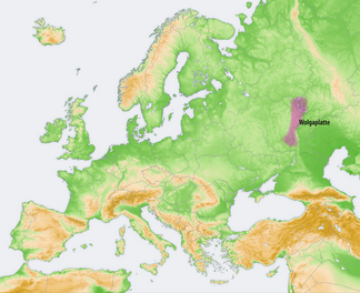
Volga plate
| Volgaplatte (Volga heights) | |
|---|---|
|
Location of the Volga plate |
|
| location | Russia |
| Coordinates | 53 ° 7 ' N , 46 ° 36' E |
| rock | Sedimentary rocks |
| Age of the rock | Carboniferous to Paleogene |
The Volga plateau (also called Volga heights , Russian Приволжская возвышенность , Priwolschskaja voswyschennost ) is a very elongated mountain range up to 375 m high in the European part of Russia .
The Volga plate is part of the great Eastern European plain . It is located west of the Volga River between the cities of Kazan in the north and Volgograd in the south. The mountain landscape, which slopes down to the right (western) bank of the Volga with a steep mountain bank and forms the eastern boundary of the Volga plateau, lies opposite the mostly flat left (eastern) meadow bank .
Near the surface, the Volga plate mainly consists of Mesozoic to Palaeogene sandstone , claystone , marl , chalk and Opoka . Only in a few places, in the area of tectonic bulges, do limestone and dolomite from the Carboniferous and Upper Permian come to light.
The low mountain range landscape of the Volga plateau is characterized by hilly and mountainous areas in which smaller and larger rivers have dug themselves. These include Chopjor , Medvediza and Sura , among others . As an artificially created waterway, the Volga-Don Canal , which was built on the border of the Volga Plateau and the Jergeni Hills adjoining it to the south , connects the rivers in an east-west direction , as indicated by its name.
While the Volga plateau is only sparsely populated, there are large cities on the edge of the ridge and on the banks of the Volga. These are among others (from north to south) Kazan , Ulyanovsk , Saransk , Penza , Syzran , Saratov and Volgograd .
Individual evidence
- ↑ Article Volga Heights in the Great Soviet Encyclopedia (BSE) , 3rd edition 1969–1978 (Russian)
- ↑ mountain and meadow bank : Diercke world atlas , Georg Westermann Verlag, Braunschweig, 184. edition, 1976 ISBN 3-14-100000-X , p 61, quadrant I2 to H3
