Zwieselbacher Rosskogel
| Zwieselbacher Rosskogel | ||
|---|---|---|
|
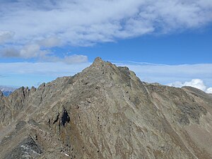
Zwieselbacher Rosskogel from the south, from the Gleirscher Rosskogel. To the right of the main summit the north summit can be seen with a summit cross. |
||
| height | 3081 m above sea level A. | |
| location | Tyrol , Austria | |
| Mountains | Stubai Alps | |
| Dominance | 3.7 km → Vordere Sonnenwand | |
| Notch height | 330 m ↓ Gleirschjöchl | |
| Coordinates | 47 ° 9 '46 " N , 11 ° 2' 51" E | |
|
|
||
| First ascent | August 23, 1881 by Ludwig Purtscheller with Franz Schnaiter (tourist) | |
| Normal way | From the Schweinfurter or the Pforzheimer Hütte over the notch directly north of the summit. | |
The Zwieselbacher Rosskogel is 3081 m above sea level. A. high, double-peaked mountain in the northern Stubai Alps in Tyrol . The summit offers a very comprehensive view to the north, as there are no higher mountains obscuring the view. To the south, however, the view is limited by the higher peaks of the Stubai Alps. The first known ascent took place on August 23, 1881 by Ludwig Purtscheller , accompanied by the chamois hunter Franz Schnaiter from Zirl .
Location and surroundings
The Zwieselbacher Rosskogel is located in the area of three high valleys: to the north of the summit is the Kraspes , to the east the Gleirschtal , both side valleys of the Sellrain . To the west of the mountain lies the Zwiselbachtal , a side valley of the Horlach valley , which flows into the Ötztal below Niederthai . From the north-south ridge that separates the Zwieselbach and Gleirschtal valleys, a side ridge branches off at the Zwieselbacher Rosskogel in a north-easterly direction, with the Rotgrubenspitze ( 3,040 m ) just under a kilometer away, another, somewhat lower three-thousand-meter peak. In the ridge north of the summit are the Weitkarpitzen (up to 2947 m ) and the Kraspesspitze ( 2954 m ). In the clearly pronounced ridge running to the south there is another more striking peak at a distance of about 750 meters with the Gleirscher Rosskogel ( 2994 m ).
The small Kraspesferner is nestled between the ridge running to the north and northeast , for which an area of 0.69 km² was determined in 1969, but which is severely affected by the retreat of the glacier .
Increase opportunities
A marked trail leads over the plateau-like notch immediately north of the summit between Zwieselbacher Rosskogel and Weitkarspitzen , which serves as a transition between the Schweinfurter Hütte in the west and the Pforzheimer Hütte in the east. From this notch, the slightly lower north summit (about 3070 m ), which carries the summit cross, can be reached in a few minutes. The also quite short transition from the north summit to the slightly higher south summit requires somewhat easy climbing. It takes about three hours to get to the top from both huts.
Another varied option is the ascent over the south ridge from Gleirscher Jöchl ( 2750 m ) over Gleirscher Rosskogel . The first climbers Purtscheller and Schnaiter reached the summit via this route. The most difficult sections of the ridge, especially the flat steep upswing immediately south of the main summit, were defused in 2010 by members of the Pforzheim section of the Alpine Club by installing appropriate climbing aids, and the route known as “Via Mandani” is continuously marked. Despite the climbing aids, the ridge , which is somewhat exposed in places, shows climbing difficulties of grade II .
The Zwieselbacher Rosskogel is extremely popular as a ski tour , and there are numerous routes. The most common route is from the north, from Haggen through the Krapsestal.
Individual evidence
- ↑ Clem Clements, Jonathan de Ferranti, Eberhard Jurgalski , Mark Trengove: The 3000 m SUMMITS of AUSTRIA - 242 peaks with at least 150 m of prominence , October 2011, p. 11.
- ↑ a b Georg Jäger: Alpine history in a nutshell. Sellraintal region. Austrian Alpine Association, Innsbruck 2015, p. 38 u. 48f ( online (PDF; 2.1 MB) ( Memento from February 5, 2016 in the Internet Archive ))
- ↑ Federal Office for Metrology and Surveying Austria: Zwieselbacher Rosskogel on the Austrian Map online (Austrian map 1: 50,000) .
- ^ National Snow and Ice Data Center: World Glacier Inventory. Boulder (Colorado, USA) 1999, updated 2012, doi : 10.7265 / N5 / NSIDC-WGI-2012-02
- ^ Mark Zahel: Ötztal: Ötztal Alps - Stubai Alps. Bergverlag Rother, Munich 2015, ISBN 3-7633-4461-6 , p. 72f ( Google books )
- ↑ a b Klier: Alpine Club Guide Stubai Alps. 2006, p. 203f, see literature
- ↑ almrausch.at: Gleirscher Rosskogel (Pforzheimer Hut), 2994 m
- ↑ Markus Stadler: Munich ski touring mountains: 92 fantastic ski touring destinations. Bergverlag Rother, Munich 2012, ISBN 3-7633-3065-8 , p. 300ff ( Google books )
Literature and map
- Walter Klier : Alpine Club Guide Stubai Alps. Bergverlag Rudolf Rother , Munich 2006, ISBN 3-7633-1271-4
- Alpine Club map sheet 31/2, 1: 25,000, Stubai Alps; Sellrain. ISBN 3-928777-73-4


