Kétsoprony: Difference between revisions
Content deleted Content added
Replacing BekesCounty.gif with File:BekesCounty.png (by CommonsDelinker because: file renamed or replaced on Commons). |
change to svg coat of arm |
||
| (One intermediate revision by one other user not shown) | |||
| Line 5: | Line 5: | ||
|subdivision_name = {{HUN}} |
|subdivision_name = {{HUN}} |
||
|coordinates = |
|coordinates = |
||
|image_shield = |
|image_shield = HUN Kétsoprony COA.svg |
||
<!--If coordinates are filled in above remove ed notes from "Hungary" in pushpin_map field to display map--> |
<!--If coordinates are filled in above remove ed notes from "Hungary" in pushpin_map field to display map--> |
||
| Line 37: | Line 37: | ||
==Population== |
==Population== |
||
| ⚫ | |||
<center> |
|||
| ⚫ | |||
|- |
|- |
||
!Year|| 1980|| 1990|| 2001|| 2010|| 2011|| 2013 |
!Year|| 1980|| 1990|| 2001|| 2010|| 2011|| 2013 |
||
| Line 45: | Line 44: | ||
|- |
|- |
||
|} |
|} |
||
</center> |
|||
==References== |
==References== |
||
Revision as of 08:17, 9 October 2022
You can help expand this article with text translated from the corresponding article in Hungarian. (December 2013) Click [show] for important translation instructions.
|
Kétsoprony | |
|---|---|
| Country | |
| County | Békés |
| Area | |
| • Total | 51.24 km2 (19.78 sq mi) |
| Population (2013) | |
| • Total | 1,348 |
| • Density | 26.3/km2 (68/sq mi) |
| Time zone | UTC+1 (CET) |
| • Summer (DST) | UTC+2 (CEST) |
| Postal code | 5674 |
| Area code | 66 |

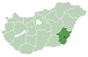
Kétsoprony is a village in Békés County,[1] in the Southern Great Plain region of south-east Hungary.
Geography
It covers an area of 51.24 km2 (20 sq mi) and has a population of 1,348 people (2013 estimate).[2]
Population
| Year | 1980 | 1990 | 2001 | 2010 | 2011 | 2013 |
|---|---|---|---|---|---|---|
| Population | 1,633 (census)[2] | 1,542 (census)[2] | 1,559 (census)[2] | 1,469 (estimate)[3] | 1,359 (census)[2] | 1,348 (estimate)[2] |
References
- ^ "Kétsoprony City Info". CitySeek.org. Retrieved 9 December 2013.
- ^ a b c d e f "Kétsoprony Population Table". citypopulation.de. Retrieved 9 December 2013.
- ^ "Helységnévkönyv adattár 2010". KSH (Hungarian Central Statisctical Office). 1 January 2010. Archived from the original on 7 November 2012. Retrieved 9 December 2013.
46°43′N 20°52′E / 46.717°N 20.867°E


