Mikófalva: Difference between revisions
Content deleted Content added
Do not emphasize nationality without good reason, Script-assisted fixes: per MOS:NUM, MOS:CAPS, MOS:LINK |
m →References: stub sorting |
||
| (One intermediate revision by one other user not shown) | |||
| Line 44: | Line 44: | ||
| iso_code = |
| iso_code = |
||
| website = http://www.mikofalva.hu/ |
| website = http://www.mikofalva.hu/ |
||
}} |
}} |
||
'''Mikófalva''' is a village in [[Heves County]], Hungary.<ref>{{cite web | url=http://www.ksh.hu/apps/!cp.hnt2.telep?nn=14076 | title=Central Statistical Office | work=KSH | accessdate=22 December 2017}}</ref> |
'''Mikófalva''' is a village in [[Heves County]], Hungary.<ref>{{cite web | url=http://www.ksh.hu/apps/!cp.hnt2.telep?nn=14076 | title=Central Statistical Office | work=KSH | accessdate=22 December 2017}}</ref> |
||
| Line 53: | Line 53: | ||
{{Bélapátfalva District}} |
{{Bélapátfalva District}} |
||
{{Heves}} |
{{Heves}} |
||
{{authority control}} |
|||
{{DEFAULTSORT:Mikofalva}} |
{{DEFAULTSORT:Mikofalva}} |
||
[[Category:Populated places in Heves County]] |
[[Category:Populated places in Heves County]] |
||
{{ |
{{Heves-geo-stub}} |
||
Latest revision as of 21:56, 20 October 2022
Mikófalva | |
|---|---|
Village (község) | |
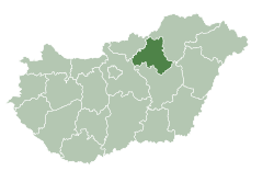
 Location of Heves County in Hungary | |
| Coordinates: 48°03′18″N 20°19′12″E / 48.05500°N 20.32000°E | |
| Country | Hungary |
| Region | Northern Hungary |
| County | Heves County |
| District | Bélapátfalva |
| Government | |
| • Mayor | Fónagy Gergely (Ind.) |
| Area | |
| • Total | 14.41 km2 (5.56 sq mi) |
| Population (2015) | |
| • Total | 698 |
| • Density | 48/km2 (130/sq mi) |
| Time zone | UTC+1 (CET) |
| • Summer (DST) | UTC+2 (CEST) |
| Postal code | 3344 |
| Area code | 36 |
| Website | http://www.mikofalva.hu/ |
Mikófalva is a village in Heves County, Hungary.[1]
References[edit]
- ^ "Central Statistical Office". KSH. Retrieved 22 December 2017.


